Active volcanoes can be incredibly dangerous, especially to those who live nearby, but how do you get close enough to observe one in action? Matthew Watson explains how artificial drones are providing volcanologists with insights that could one day save human lives
Volcanoes are intractable, majestic and enigmatic and there is something both primal and terrifying about watching them erupt, even at a safe distance. The juxtaposition of beauty and danger is a heady mix and many people, tourists and scientists alike, are drawn, inexorably, towards them. With that powerful attraction, however, comes risk.
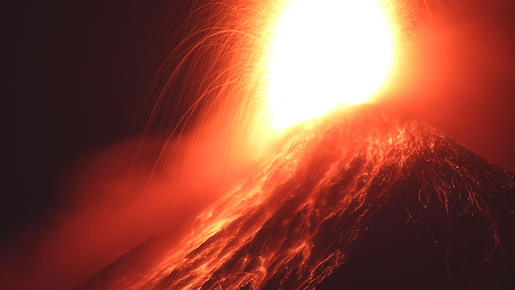
Take the Volcán de Fuego in Guatemala, which rises sharply out of a gently sloping terrain of rich, lush volcanic soil covered in sugar-cane fields. It is an active volcano that has erupted violently more than 30 times in the last two years, and from the observatory where I’m staying, new sunlight bathes its peak, while the steaming plume emanating from the summit appears to glow.
Insects buzz, and students rustle in their sleeping bags as the first light catches their tents. The smell of coffee, good coffee, pervades the air. As a tractor, laden with cane farmers, chugs slowly past, it is impossible not to feel inspired by the backdrop. I know their day will be tougher than mine, but I retreat in solace to thinking about how our research should make them safer.
Deadly location
I am in Guatemala with a group of other volcanologists and engineers from the UK, and we are here to work with local scientists to investigate the volcano’s current activity and to examine how emissions from it affect the local population. It’s vital work because if Fuego erupted as strongly as it did in October 1974, the blast would devastate Guatemala and its people, more than 100,000 of whom now live within 10 km of the summit.
Among the dangers are the deadly avalanches of hot gas and rock that occur with alarming regularity. Indeed, these “pyroclastic density currents” (PDCs) are the biggest killers from volcanoes. Then there are the large mudslides that cascade down Fuego’s flanks every rainy season. Finally, there is the fine ash, which is produced whenever the volcano erupts and carpets the entire area, including local villages. Although it’s responsible for the wonderfully fertile local soil, the ash risks the health of those who breathe it in.
There is a lot we still need to know about the volcano’s activity and its hazards. In particular, we want to learn how to predict when the next eruption will occur and which valley any lava and PDCs will flow down. Our aim in regularly monitoring Fuego is therefore to get a better understanding of the volcano so that local people can take the best possible decisions next time it erupts. Unfortunately though, our task is not as simple as it sounds.
The summit of the Fuego volcano is inaccessible; it’s just too dangerous to get to the very top. You can’t get closer than 1 km from the peak and the nearest villages lie about 6 km away. This year we’ve therefore come armed with three different types of drone – or unmanned aerial vehicle (UAV), to use the jargon. It’s not the first time people have flown drones over volcanoes, but ours are geared more for research. So far we’ve used off-the-shelf cameras that can collect live data but we’re also developing different types of more specialized cameras to capture information.
During our first drone mission, we get a good view of the summit crater. Gustavo Chigna, Guatemala’s leading volcanologist and my collaborator for nearly 20 years, smiles broadly. He tells us it’s the first time he’s seen the summit in five years, the previous occasion being with a fixed-wing plane. The beauty of drones is that they give volcanologists a new, low-risk way of accessing volcanoes. Indeed, we’re moving beyond simply observing volcanoes with drones and starting to carry out proper, scientific measurements.
Fuego is an incredibly dynamic volcanic system. Its topography changes on timescales so rapid they feel alien to the two geologists on our team. Outcrops – exposed deposits from previous eruptions – are transient, sometimes vanishing in a single rainy season. As for the seven or eight valleys carved into Fuego’s side, they are constantly being filled by PDCs and eroded by mudslides. If a valley is full of material, the next flow might instead pour down the mountainside, which means that the valley and the local gradient of Fuego dictate the exact nature of any hazardous flows .
One project we’ve been working on is to create a detailed 3D topographical map of Fuego, which we would use to calculate how material flows down the sides of the mountain when it erupts. Unfortunately, an individual 2D image taken by a drone is not enough on its own. Using it to work out how lava flows down the mountain would be like pouring a cup of coffee on a flat photograph rather than over a papier-mâché model of the volcano. We therefore take many images of Fuego from about 60 different viewpoints and combine them using an off-the-shelf software package, such as Agisoft, in a process called structure from motion (SfM).
To do this, we need to know the precise location of the drone each time it captures an image, which we obtain using GPS trackers attached to the drone. The resulting map, or topographic digital elevation model (DEM), can be created in a few hours while we’re out in the field and consists of an array of numbers each of which corresponds to an elevation at a particular point on the volcano. Thanks to close-up pictures of the volcano taken by the drone (figure 1), each map has a resolution of a few centimetres, which is far better than the 30 m value from commercial DEM packages.

In practice, it is not easy to map those parts of the volcano where the drone images have low contrast (such as older lava flows), contain transparent bits (such as the plume), or have few features present. However, we can calculate the topography of valleys quickly and easily as they have good contrast and we’re mapping something solid, rather than a fluid-like plume. This work raises the tantalizing possibility of one day being able to map valleys in real time and so produce much more accurate predictions of where and how far material will flow. Our work is revolutionizing hazard prediction from volcanogenic flows.
Analysing the ash
Volcanologists don’t just rely on optical measurements, however. Ground-based cameras and satellite sensors can yield information about volcanoes at ultraviolet and infrared wavelengths too. So by using drones, we now have another way of studying volcanoes using these radiation bands.
Infrared light is particularly valuable as we can use it to calculate the heat flux from a volcano, to map and model the flow of lava, and to determine the composition of the lava from the precise frequencies the volcano emits. We can also use this infrared light to measure the amount of ash, carbon dioxide, sulphur dioxide and other gases, by working out how strongly they scatter and absorb thermal infrared light. Indeed, the beauty of using drones is that they give us a way of verifying satellite measurements of the amount of ash emitted by volcanoes. Whether the drones match the satellite data or tell a different story, however, is something we can’t yet tell.
The other important aspect of observations of volcanic emissions is that they are a proxy for what’s happening out of view. For example, in a volcano with an open vent that is producing sulphur dioxide, any jump in the rate of emission tends to signify that the volcano is about to erupt. Conversely, if the vent closes up, any drop in emissions could mean pressure is building up and the volcano is about to explode.
We shouldn’t forget either that volcanic emissions are dangerous. Gases such as sulphur dioxide are toxic to humans, plants and animals, while the ash particles, if small enough, can cause cancer. And if the ash ends up in the engine of an aeroplane that happens to be flying by, it can damage the turbine and, in extreme cases, cause it to cut out entirely. Rain can also turn ash into catastrophic mudslides, potentially sending it tens of kilometres further afield, creating a secondary hazard to people living relatively far from the volcano. Estimates suggest there’s enough ash on the flanks of Fuego to generate mudslides for the next 20 years, even if the volcano never erupts during that time.
Unfortunately, there are big uncertainties when using infrared observations to determine the size distribution of volcanic ash particles as we have only a handful of wavelength bands at our disposal. These particle-size distributions are important as they are largely responsible for dictating the fate of an ash cloud and are an important parameter in models that predict where ash goes in the atmosphere after an eruption. In fact, until recently, volcanologists relied on a particle-size distribution in the range 1–100 µm that had been measured in 1989 by Peter Hobbs, an atmospheric scientist from the University of Washington in the US, which was used to manage large swathes of global airspace. The problem is that this single distribution is unlikely to be characteristic of all ejected volcanic ash, which depends a lot on the amount and crystalline structure of silica in a volcano, as well as on how it erupts.
Another key aim of our project at Fuego has therefore been to capture and examine volcanic ash in situ using drones. It’s been done before using balloons flying over a number of volcanoes in places such as Costa Rica and Indonesia, but those missions have only been at high altitude – typically about 10 km up. That makes it tricky to control a balloon so that it flies where you want it to go; although it will fly rapidly through a plume in a horizontal direction, if you happen to miss the plume, you can’t redirect the balloon.
During our last trip the engineers on our team managed to get a drone known as a “quadcopter” close enough to make observations of Fuego’s vent and of the plume of gas from a second volcano, Pacaya. We also flew a fixed-wing aircraft through Fuego’s ash clouds for the first time.
The future’s up in the air
Drones are giving volcanologists unprecedented access to – and high-quality data for – areas that were unthinkable even a decade ago. My prediction is that it will become routine to use drones to monitor volcanoes over the next few decades – all we need is for physicists, engineers and geologists to continue working together. In the short term, my colleagues and I are all heading back to Guatemala later this autumn to continue our effort. We’re all excited by the prospect, and can’t wait to get back into the air.
How to study volcanoes with drones

The engineers on the UK team studying the Volcán de Fuego in Guatemala have trialled three systems for flying over this dangerous volcano, all of which are powered by electric engines. The first is an off-the-shelf DJI Phantom 3 Pro quadcopter with a standard 4K camera (bottom right in photo). This drone has let us create 3D maps, known as digital elevation models, of both the summit crater and the valleys down which hazardous material travels. These models have, in turn, helped us make predictions about the timing and direction of the next eruption and what materials it might contain. To this system we’ve also added an infrared camera from the US firm Therm-App, which we’ve used to survey lava flows. Unfortunately, we can’t add any more kit as the quadcopter’s maximum payload is only 300 g.
The second system we’ve used is a Ritewing Zephyr 2 delta-wing aircraft (bottom left in photo), which has a wingspan of 1.5 m and can carry a payload of 800 g. We have used it to collect ash samples from the volcano by sticking adhesive tape on its leading edges and installing a filter pack with pump on the front. The craft also has a series of lightweight sensors that monitor air pressure, temperature and relative humidity. The beauty of this system is that because the ash sensors are on the front but the craft is powered by a rear-mounted propeller, we reduce the number of fine particles lost from air disturbance.
Our final system for studying the Volcán de Fuego is a small glider known as a Thermik XXXL (rear of photo). Launched using a catapult, it has a 5 m wingspan and can carry a 1.1 kg scientific payload. Although this craft has a front-mounted propeller, it can be folded backwards in flight so the aircraft glides through the plume. We’ve already trialled the glider and our plan now is to fit it with both gas and ash sensors, along with a pointable infrared camera.
- Enjoy the rest of the July 2017 issue of Physics World in our digital magazine or via the Physics World app for any iOS or Android smartphone or tablet. Membership of the Institute of Physics required