“I wander’d lonely as a cloud…,” wrote William Wordsworth in the early 19th century, but didn’t specify what type; all we know is that it “floated on high o’er vales and hills”. That’s fine for a poem but not enough detail for today’s climate modellers – the size, shape and composition of a cloud all alter the way it reflects light and heat. And clouds vary widely. Some help cool the Earth by reflecting heat back to space, others act like a blanket, trapping warmth at the surface. Time is a factor too; some clouds persist whilst others are ephemeral.
All this makes clouds tricky. Arguably some of the most vexing form at the ends of the Earth – over the Southern Ocean and the Arctic. They appear to be made to an unconventional recipe and climate models struggle to reproduce them. But in recent years there’s been progress in understanding how these clouds develop.
Let’s start with the south. At any one moment clouds blanket about 90% of the Southern Ocean. Given that this ocean – situated roughly between 40°S and 70°S – covers around 15% of the Earth’s surface, that’s a serious amount of cloud. It’s generally low-lying, a formation that bounces the Sun’s rays back to space and keeps the Earth cool. Over the course of one year, low clouds above the Southern Ocean reflect around one third of the solar energy that falls there: that’s 5320 TW or roughly 350 times mankind’s annual power consumption.

Atmospheric electricity affects cloud height
Climate models, however, tend to underestimate how reflective these clouds are. So they overestimate ocean surface temperatures in this region by as much as 3 °C. In turn this leads to errors in estimates of sea ice, biochemical cycles in the ocean, the jet stream path, storm tracks and future climate predictions. That’s quite an escalation and it warranted investigation.
Clean air
Ben Murray, from the University of Leeds, UK, and colleagues had a hunch that these Southern Ocean clouds may be unusual because of the purity of the air. The lack of land here, along with the prevailing wind patterns, means that air is very clean compared to other regions.
Clouds are created when warm air rises, expanding and cooling as it goes. Cooler air can’t hold as much water vapour so some of the vapour condenses onto pieces of dust, creating water droplets or ice crystals. Once billions of droplets have formed the cloud becomes visible. Crucially, the minute pieces of dust and air pollution found in most parts of the world act as a focal point for ice crystals, and actively aid cloud formation. But the clean air over the Southern Ocean means clouds have to follow a different recipe.
“The Southern Ocean clouds have 1000 to 10,000 times less ice-nucleating particles than in terrestrial environments,” says Jesus Vegara-Temprado, who did his PhD at Leeds and is now at ETH Zurich, Switzerland.
A carpet of twinkling green lights in front of them, something like the effect produced by a ‘disco’ ball
Ryan Neely III
Vegara-Temprado explored how clouds in this region evolve using a high-resolution numerical weather prediction model together with microphysics calculations and estimates of atmospheric particle concentrations. The team’s simulations, published in PNAS, showed that this low-particle environment most commonly produced bright and reflective stratus clouds, like those seen on satellite photos of the region, but until now poorly represented in climate models. The low concentration of ice-nucleating particles inhibits the formation of ice crystals, which reduces the chance of precipitation because ice crystals are particularly effective at gathering more moisture and helping droplets grow big enough to fall as rain. The researchers also found that the large number of liquid droplets increases the amount of reflection back to space, making the clouds brighter and longer-lasting.
Although some of the clouds can be large – up to the size of the UK – it’s too expensive to include the detailed microphysical processes that produce them in today’s climate models. “Many climate modellers are currently trying to improve the representation of these particles and the way different processes happen in clouds, but this will take some years,” says Vegara-Temprado.
Up north
It isn’t just the Southern Ocean where these “clean” clouds cause strife for climate modellers. Ice formation processes are also critical over the Arctic region, as Ryan Neely III from the University of Leeds and colleagues from around the world have discovered. Since 2010 Neely has studied clouds from one of the most extreme places on Earth: the summit of the Greenland ice cap.

Here, at 3216 m above sea level, lies the highest altitude observatory in the Arctic. The Greenland Ice Sheet is such a large and distinctive feature that it has a strong influence on atmospheric currents such as the jet stream. Satellites struggle to distinguish clouds from the highly reflective ice surface, so there’s a need to make observations from the ground. Following an ice core drilling program in 1989, the Greenland summit became a hub for regional science projects, and its distinctly continental position – more than 400 km from any coastline – makes it an ideal location to study the atmospheric structure and clouds over the ice sheet.
“Logistically it is hard to get there because you either have to fly specialised aircraft when the weather allows or take [a] month-long journey with a convoy of large tractors and other machinery across the ice sheet,” says Neely. Transporting Neely’s equipment, including a portable laboratory on skis that holds an array of state-of-the-art lidar and radar kit, was a major challenge, requiring the US military’s LC-130 – a plane with retractable skis. “The LC-130s only work in the summer when it is warm enough for them to land,” says Neely. “Besides the cold, it is also difficult for the planes to land because Summit is so high and the air is thin. Summit has the longest runway in the world.”
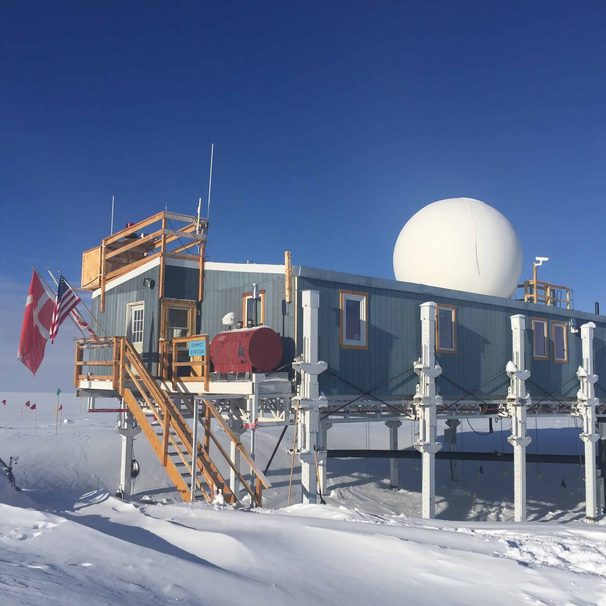
Since 2003 the Summit Station has been a year-round observatory. For the past eight years, Neely and his team have measured the clouds, precipitation and state of the atmosphere here. Twice a day they send up a radiosonde balloon, which records temperature, pressure, relative humidity and windspeed at a range of altitudes. Various lidar and radar systems monitor the sky continuously, enabling scientists to build up a picture of the atmosphere from the reflection patterns of their laser beams and sound waves.
Just right
During 2012 a summer heatwave resulted in a major melt event on the Greenland Ice Sheet. Neely’s colleagues were able to show that the warming was enhanced by “Goldilocks” clouds overhead, which contained just the right amount of supercooled liquid water to encourage formation of large ice crystals and help let the Sun’s radiation travel through the cloud, but also happened to be just thick enough to trap the heat underneath them. As in the clouds in the Southern Ocean, the proportion and type of ice-nucleating particles were a crucial part of the recipe for these clouds; any fewer and the cloud might not have formed; any more and the droplets might have grown too fast and created rain.
Subsequently, the scientists monitored how common these Goldilocks clouds are. “We observe them at the Summit Station over a third of the time during summer, and in other Arctic locations vulnerable to warming, such as over the Beaufort Sea and east Siberian Sea, we see them occurring 20 to 50% of the time in summer,” says Neely, who published his findings in Nature in 2013.
During the winter of 2016/17, a strange phenomenon enabled the team to gain a greater understanding of what makes some clouds more prone to warming the Earth’s surface. “One evening the scientists emerged from the mobile laboratory to see a carpet of twinkling green lights in front of them, something like the effect produced by a ‘disco’ ball,” says Neely. Ordinarily cloud reflects only a small fraction of the green lidar beam back to Earth; most light is reflected and bounced around in other directions. But on this particular evening the ice crystals in the cloud above were mainly orientated horizontally, producing “rave ice”, as the scientists like to call the phenomenon.
“The patterns that we observe on the ground tell us about the shape, size and orientation of crystals and how perfectly formed they are,” says Neely. The team has now observed rave ice on numerous occasions during the winter. “It’s interesting because we think that clouds with more horizontal crystals like this are associated with warming, because they are more likely to reflect visible light and heat,” explains Neely, who published the discovery in Applied Optics.
For Neely and his team it is still early days – it will take many more years of measurements and analysis before it becomes clear what is normal for clouds, and what is exceptional. This year the team is back up north, travelling on a Swedish ice-breaker ship and measuring clouds and aerosols up near the North pole. “These clouds are critical for the sea ice, but we do not understand where the ice particles come from,” says Murray. Back on dry land the scientists are working with climate modellers to improve the way that climate models represent these unconventional yet important clouds.