Researchers in Japan and France have discovered a new way of looking inside the Earth that will no longer be hampered by “tectonic blind spots”. Exploiting a curious phenomenon known as the Earth’s “hum”, the technique could give geophysicists the most extensive picture yet of the upper mantle – the zone in which earthquakes originate.
Earth journeys
In Jules Verne’s science-fiction classic of 1864, an intrepid professor embarks on a curiosity-driven Journey to the Centre of the Earth. While this type of exploration has remained firmly in the realms of fiction, scientists have since found an indirect means of “seeing” beneath the Earth’s surface. Studying how earthquake-driven shock waves travel through the planet has provided geophysicists with a basic picture of the Earth’s interior.
The limitation with this method of imaging, however, is that it is restricted to the zones where earthquakes occur, the vast majority of which are concentrated along plate boundaries. What is more, the technique can only be deployed when seismic activity is occurring – earthquakes are notoriously difficult to predict and they can strike in zones that have been seismically quiet for very long periods.
Now, Kiwamu Nishida at the University of Tokyo and his colleagues have realized an alternative way to image the Earth that is not reliant on the presence of earthquakes. The geophysicists instead track surface waves generated through the interaction of the Earth’s atmosphere and surface – a phenomenon known as the Earth’s seismic “hum”.
Mother Nature calls
Strange as it may seem, the Earth’s atmosphere continuously rings out in a chorus of frequencies just below the reach of the human ear. This phenomenon is expressed at the Earth’s surface as “infrasonic” waves – that is, waves with frequencies ranging 0.01–10 Hz – that are known to exist from acoustic recordings around the globe.
Until now, however, researchers have been unable to link variations in the Earth’s hum with features in the mantle. This is largely because of the complicated processes involved the hum’s generation and the presence of various other sources of ambient seismic noise.
Nishida and his team get around this problem by studying records of the Earth’s ambient noise over a long time period – between 1986 and 2003. In this way, they were able to disentangle the hum from the different sources of ambient noise and observe how it varied over periods of 100–400 s. They could then link fluctuations and geographical variation in the hum with the physical and chemical composition of the mantle.
Mapping the mantle
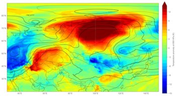
The geophysicists measured the speed of sound in the mantle to depths of 340 km beneath Asia, North and South America and Australia. By combining a large set of data in a form of tomography, they were able to build up velocity maps of the mantle beneath these continental land masses. “Using seismic hum, estimation of Earth’s structure is not limited by spatial distribution of earthquakes,” Kiwamu told physicsworld.com.
Sebastian Rost, a geophysicist at the University of Leeds in the UK, is impressed by the new development and sees a lot of potential. “Understanding the structure of the upper mantle is important to better understand plate tectonics, especially the way subducted plates are recycled at subduction zones and new crust is generated at mid oceanic ridges.”
Rost is slightly concerned, however, that the researches require a seven year timescale in order for the technique to work. “Seismic data are lost every day due to archive being closed to save money or decaying magnetic tapes or data not available for research in the first place.”
This research appears in the latest edition of Science.