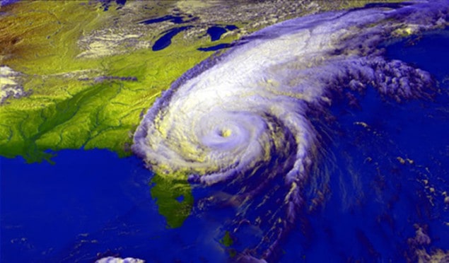
The mystery of how tropical cyclones deliver colossal amounts of rainwater over long periods of time may have been solved by an international team of atmospheric physicists. The team suggests that – rather than relying on ongoing evaporation to replenish rainwater – these powerful storm systems suck pre-existing moisture out of the air through which they travel.
Tropical cyclones – or hurricanes, as they are called in the northern hemisphere – are capable of delivering huge amounts of rain that can do more damage than the high winds associated with the storms. The mean precipitation from a typical Atlantic hurricane, for example, lies at around 2 mm/h – and this rate can be sustained for days on end. What is puzzling about this, however, is that it is considerably faster than the typical rate of tropical oceanic evaporation. This means that a hurricane’s moisture stocks must be replenished from something other than ongoing evaporation, otherwise a typical storm would run dry within a day.
Imported moisture
Traditionally, studies of the water budget of tropical cyclones have been focused only on the area within 400 km of the storm’s centre – the part of a cyclone thought to receive the majority of the ocean-derived heat that powers it. In this region, the local evaporation of water from the sea can only account for around 10–20% of the total rainfall. So, it has been supposed, the additional moisture must be being imported from further out, up to 2000 km from the eye of the storm – and well beyond the area of the storm in which rain falls. The exact mechanism that could import water vapour like this has not been clear. Pressure gradients more than a few hundred kilometres from the storm’s centre, for example, are inadequate to drive outlying moist air towards the centre.
To investigate further, physicist Anastassia Makarieva of the Petersburg Nuclear Physics Institute in Russia and colleagues looked at the moisture dynamics of north Atlantic hurricanes out to 3000 km from their centre. First, the researchers considered the radial pressure distribution, relative humidity and temperature of the hurricane boundary layer, and calculated that – even at their wider scale of interest – the storm’s rainfall cannot be supported by evaporation alone.
Dry footprint
Next, the team examined North Atlantic atmospheric moisture and rainfall data from 1998 to 2015 recorded by the Tropical Rainfall Measuring Mission satellite and NASA’s Modern Era Retrospective Re-Analysis for Research and Applications programme. By comparing conditions during hurricanes with the surrounding hurricane-free periods, the researchers were able to show that hurricanes leave in their wake a “dry footprint”, in which rainfall is suppressed by up to 40%.
Given this – and the failure of evaporation to adequately explain how hurricanes refuel – the researchers propose instead that hurricanes gobble up pre-existing moisture stocks from the atmosphere as they move, with the rain potential of the hurricane being directly proportional to the storm’s velocity relative to the surrounding air flow.
“Hurricanes must move to sustain themselves,” Makarieva says, concluding: “Hence, how they move and consume the pre-existing atmospheric water vapour is key to predicting their intensity.” The researchers propose that – rather than being driven by heat extracted from the ocean – hurricanes are instead powered by releasing the potential energy of the water vapour previously accumulated in the atmosphere that they pass through.
Moisture-robbing winds
They suggest this could explain why tropical cyclones do not occur in regions like the Brazilian coast where there are persistent, landward winds that remove water vapour from over the ocean – thereby robbing the potential storms of their drive and fuel source.
Patrick Fitzpatrick, a geoscientist from the Mississippi State University who was not involved in this study, comments: “Quantitative precipitation forecasting of tropical cyclones still lacks skill, and is worthy of research since these storms’ inland flash flooding is a major cause of casualties and property damage”. He believes that further investigation of these new climate budget implications – considering the local upstream conditions and storm motion – are needed.
Kevin Trenberth – a meteorologist at the US National Center for Atmospheric Research – is sceptical, however, suggesting the researchers are too idealistic in their view of hurricanes, treating them as symmetrical and two dimensional, and overlooking their size variability and spiral arm bands that bring moisture into the storm from about four times the radius of the rainfall area. The mismatch between evaporation and precipitation rates for anything greater than light rain has already been established, he says, adding: “It is correct that the moisture has to come from somewhere, and movement of the storm helps, but that does not help storms that move slowly or not at all.”
With their initial study complete, the researchers are now working to describe how hurricanes might develop over time by the condensation of water vapour.
The research is described in the journal Atmospheric Research.


