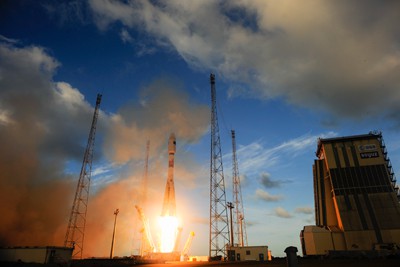
The European Space Agency (ESA) has launched the first satellite belonging to a dedicated programme that will monitor the Earth in unprecedented detail. Launched yesterday on a Soyuz rocket from Europe’s spaceport in Kourou in French Guiana, Sentinel-1 will, among other things, study sea ice in the Arctic and map land surfaces, including forests, water and soil. It is the first part of the Copernicus programme – a fleet of satellites that will be launched in the coming decade.
Measuring 2.8 m long, 2.5 m wide, 4 m high and weighing 2300 kg, Sentinel-1 will orbit the Earth at an altitude of 693 km. The craft carries a synthetic-aperture radar system that will study the Earth constantly throughout the day and night and in any weather. It is expected to observe the Earth for seven years, by which time the other six Sentinel craft should have launched. These include Sentinel-2, which is expected to launch next year to monitor vegetation, soil and water, and Sentinel-3, which will monitor sea- and land-surface temperatures.
Copernicus was previously known as the Global Monitoring for Environment and Security programme (GMES). Later missions such as Sentinel 4 and 5 – which will both study the atmosphere – will not be individual satellites but rather instruments that piggy-back on weather-monitoring satellites launched by the European Organisation for the Exploitation of Meteorological Satellites.
Free open data distribution
“Sentinel-1 is unique in its capacity to serve the user community with timely information, unprecedented observation frequency and free open data distribution,” Ramón Torres, Sentinel 1’s project manager told Physics World. “Although [previous missions] have facilitated scientific discoveries by thousands of investigators, no other space-borne radar system has ever been able to satisfy the needs for truly operational use in the area of timeliness, revisit rate and affordability.”
Sentinel-1 and its sister satellites build on previous European efforts to monitor the Earth, which were halted when the Envisat satellite, which launched in 2002, failed in orbit in 2012. “The Copernicus programme aims at continuation of the Envisat mission but with an operational approach and a number of smaller, more focused missions,” adds Torres.
In the first 10 hours of its flight, the spacecraft successfully unfolded its 12-m-long radar antenna and its two 10-m-long solar “wings”, which power the mission. First data from Envisat are expected to arrive within a week of launch, after which the craft will undergo two weeks of commissioning before full operation.
- There is much more about how satellites are used to monitor the Earth in this video interview with NASA’s Compton Tucker, who studies deforestation using data from space.


