An international collaboration has used a participatory rural appraisal (PRA) approach during a groundwater resources investigation in Yemen. The team, from the Netherlands and Yemen, harnessed local knowledge through a variety of PRA tools, the most informative being semi-structured interviews, transect walks, the creation of timelines and problem and solution trees.
Wahib Al-Qubatee of Wageningen University and colleagues worked in the Tihama Coastal Plain, a region bordering the Red Sea in the west of Yemen. Hydrogeological data collection has been inconsistent here despite extensive irrigation improvements upstream in Wadi Zabid and Wadi Rima in the 1970s. Local stakeholders hold a significant pool of knowledge because the irrigation systems implemented require their active participation. The people are driven by the Islamic consultation concept of “shura”, which encourages them to share knowledge and cooperate, with specialists as well as within their community.
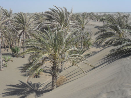
The Tihama Coastal Plain was once highly fertile agricultural land fed by water from the western slopes of the Yemen Highlands. But upstream dams and reduced rainfall have led to a shortage of both surface and groundwater, which is causing desertification.
The Yemen Highlands receive around 550 mm rainfall per year, which flows to the midstream regions of Wadi Zabid and Wadi Rima. The coast receives just 100 mm of rain each year so coastal townships such as Al-Mujaylis are heavily reliant on groundwater.
Al-Qubatee and colleagues found from interviews that 50 to 60 years ago the groundwater in Al-Mujaylis was around 0.5 m below the surface. By 2013 it was at a depth of 13 m, showing that the groundwater is being used unsustainably. There have been changes to well and pumping technology during this time, encouraged by diesel subsidies introduced by the government to support agriculture. Local people thought the drop in the water table was due to a lack of rainfall, water harvesting structures and dams in Wadi Zabid and Wadi Rima, inefficient irrigation and increased abstraction.
Using timelines the team was able to date groundwater changes by connecting them to historical events. People tended to agree that after 1985, groundwater levels and land devoted to agriculture dropped, whereas desertification and emigration increased. Following 2000, rainfall decreased, creating further pressure on the groundwater, agricultural land again decreased and crop yield also fell. Desertification became increasingly widespread.
Around this time about 60% of the population left Al-Mujaylis. The community reported that emigration was due to a decrease in crop yield exacerbating poverty. A local teacher thought that 85% of the Al-Mujaylis population live in extreme economic poverty. When groundwater was close to the ground surface, little irrigation was required. However, under current conditions watering crops is unaffordable for most: drilling and pumps may cost up to $8400. Water shortage, encroachment of sand dunes and the spread of Prosopis juliflora, a highly competitive invasive shrub, are the result.
The researchers noted that the best technique for this project was a balance between a top-down, specialist-led approach and a bottom-up method involving stakeholders. Al-Qubatee said that with this approach the researchers “benefit from the implicit knowledge of the community and get the technical expertise of governmental institutions in order to facilitate decision-making and the implementation process”. The team was pleased with the effectiveness of PRA for obtaining historical information from local people. The technique also provides an opportunity for education and for finding solutions that local stakeholders agree with.
The researchers reported their work in Water International.


