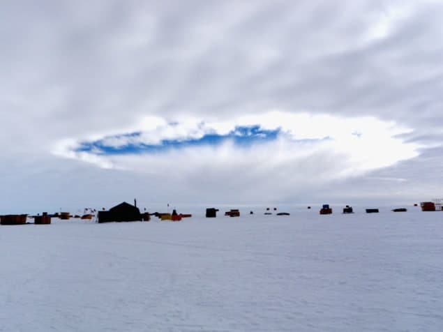
For more than 50 years it has been known that aircraft can punch large holes or carve out canals inside clouds as they pass through them – but no-one had been able to explain exactly why this happens. Now researchers in the US have identified the cause by comparing satellite images of clouds with the results of computer modelling. They say that the phenomenon could lead to extra precipitation in the vicinity of major airports.
Humans can encourage rain or snow by “seeding” clouds – dispersing small particles into the atmosphere. These particles act as nuclei onto which droplets of liquid water inside clouds can freeze, producing ice crystals that, when large enough, fall to Earth in the form of snow or rain. These droplets often exist in a “supercooled” state at temperatures as low as –38 °C and the introduction of particles into clouds raises this minimum temperature.
In the latest work, Andrew Heymsfield of the National Center for Atmospheric Research (NCAR) in Boulder, Colorado, and colleagues identify a similar process at work when aircraft pass through clouds. In this case it is not added particles that act as the crystallization nuclei but ice particles themselves. Droplets of liquid water within the clouds are frozen owing to the cooling effect of air being expanded behind propeller tips or over the wings of jet aircraft. Indeed, the former produces as much as 30 °C of cooling and the latter up to 20 °C. These ice crystals attract further droplets via evaporation, because less energy is needed to vaporize droplets over ice than is required over liquid water. Once in contact with the crystals the vapour condenses and freezes, causing the crystals to expand. The crystals then fall to Earth, creating a hole in the cloud.
Upwards and outwards
However, Heymsfield and his group believe that an additional mechanism was needed to extend this process throughout a cloud and generate a hole much larger than the aircraft itself. Their hypothesis is that the latent heat liberated when droplets freeze is enough to warm the air surrounding the ice crystals such that the crystallized region expands upwards and in so doing freezes the water droplets immediately above it. This process continues upwards until the crystallized region reaches the top of the cloud, at which point the cloudless air above forces the expanding crystallization sideways. When the crystals then fall to Earth as snow they leave a hole in the cloud that gets larger as the lateral expansion progresses.
To put the hypothesis to the test, the team used satellite images of a layer of cloud over Texas. The images, collected at 15-minute intervals over a period of four hours in January 2007, showed the growth and then disappearance of a number of holes and canals in the cloud. Canals are generated by aircraft passing through the cloud with a more horizontal trajectory.
The researchers then modelled the evolution of the cloud cover by inputting thermodynamic and wind data collected at Fort Worth in Texas into an appropriately-tuned version of the Weather Research and Forecasting model, which has been developed by NCAR, the National Oceanic and Atmospheric Administration and other American weather-related organizations. When they increased the concentration of ice crystals within the modelled clouds in line with the cooling effects expected from a passing aircraft they found that the resulting hole more than doubled in diameter, from 2 km to 4.4 km, between the 30th and the 90th minute of the simulation. This expansion was a good match to that seen in the satellite images and is therefore convincing evidence that the latent-heat hypothesis is correct, argues Heymsfield’s group.
Altering local weather
The group says that this phenomenon is unlikely to affect the global climate, but that it could alter the weather around northerly airports. The researchers used lidar and radar data to estimate the abundance of supercooled clouds within a 100 km radius of five major mid-latitude airports and two high-latitude ones. They calculated that an average propeller aircraft will seed clouds on about one of every 20 flights that it makes into or out of these airports, on the basis that they generate ice crystals at air temperatures below –10 °C, and that jet aircraft will do likewise once in every 40 flights, given that they cause crystallization only below –20 °C.
As such, says Heymsfield, increasing air traffic may mean that northerly airports will have to de-ice aircraft more often. He also says that weather data used by climate modellers that is collected at airports in the Arctic and Antarctic may have to be corrected to account for the influence of the air traffic.
Daniel Rosenfeld, an atmospheric scientist at the Hebrew University of Jerusalem in Israel, thinks that the latest research is important because, he says, the cloud-physics community had previously been “mystified” as to how aircraft could be creating “hole-punch” clouds. But he believes that the associated increase in snow or rainfall around airports is likely to be very small, particularly since most of the precipitation will evaporate before it reaches the Earth’s surface.
However, Bernhard Mayer of the Ludwig-Maximilians University in Munich believes that the effect could be significant, even if, as he points out, hole-punch clouds are rarely seen. “It could be that visible holes are just the ‘tip of the iceberg’,” he says, “and that aircraft affect clouds more often that one would infer from visual observations.”
The work is reported in Science 333 77.


