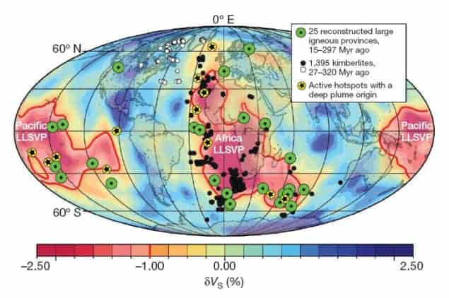
An international team of geophysicists has created a map that predicts the locations of diamonds across the Earth. This is the first image of its kind, and it is generated by linking geological processes at the surface with dynamics occurring much deeper in the planet’s interior.
“[The map] is of course very interesting for academics and how our planet works but will prove a useful exploration tool in further search for diamonds,” Trond Torsvik at the University of Oslo, who led the research, told physicsworld.com. He revealed that some of the co-authors have worked with diamond companies in Africa, which have now become of aware of this potentially useful tool.
Upwelling hot rocks
Most natural diamonds are billions of years old and typically formed in the Earth’s mantle under high pressures at depths below 150 km. The rare few diamonds that make it to the surface are elevated through the mantle by rapidly ascending magma, which cools at the surface to form igneous rocks known as kimberlites.
Torsvik and his colleagues suggest that the upwelling magma in the upper mantle is triggered by hot pulses of mantle rock ascended from far greater depths. These features of the mantle, called plumes, are believed to originate at depths of nearly 3000 km – at the boundary between the mantle and the underlying core – and they can remain fixed there for millions of years.
By contrast, the tectonic plates at the Earth’s surface are moving relative to each other by typically 0–100 mm each year. For this reason, Torsvik’s team reconstructed the movement of plates over the past 320 million years to work out the locations at the surface that have been above mantle plumes at certain times during the current geological eon. This enabled them to generate a map of the likely location of kimberlites across the Earth’s surface.
Treasures beneath Africa
The resulting map (above) shows that 80% of kimberlite locations (black dots on the map) should lie within or alongside the African continent in a relatively narrow ring. These locations lie above a stable band at the core boundary (thick red line on the map) believed to be the origin of mantle plumes. The most anomalous kimberlites younger than 320 million years (white dots on the map), are in the Slave geological region of Canada, which was close to a tectonically active continental margin at the origin of their eruption.
David Evans, a geophysicist at Yale University in the US, is impressed by the scale of this research. He cites, among other things, the group’s links with industry as a key to their success. “Torsvik was able to obtain the diamond industry database of precise ages on the kimberlites – still not publicly released in full, but evident graphically from his paper’s figures”.
This research is published in this week’s Nature.


