The iconic hydrothermal attractions of Yellowstone National Park attract millions of visitors each year. Now, using geophysical imaging, a US–Danish research team has mapped the extensive natural plumbing system beneath the park for the first time. As Yellowstone’s waters host a menagerie of hardy micro-organisms, the findings could shed light on how life emerged on the volatile early Earth.
Contained mainly within the US state of Wyoming, Yellowstone is one of the world’s largest active volcanoes. The park sits roughly 5 km above a magma chamber that is fed from below by a mantle hotspot. It has been shaped by three major eruptions in the past 2.1 million years, and water flows easily between its multiple layers of volcanic rock.
Thanks to this complex plumbing system, park visitors enjoy a witches’ brew of hydrothermal features. These include the famous Old Faithful geyser, which belches hot water and steam around 20 times a day, and roughly 500 other geysers – more than half the world’s total. Other phenomena include the evil eye-resembling Grand Prismatic Spring, bubbling mudpots and “fumarole” vents through which hot sulphurous gases escape.
Underfloor heating
The heat for all these surface phenomena stems from thermal fluids deep within the Earth’s crust. When water trickles down vertical faults created by seismic activity in the area, it ends up in the zone overlying the magma chamber. As the hot, chemically enriched fluids return to the surface, they mix with colder groundwater, leading to the surface fireworks.
Until now, however, the locations of these deep fluid pathways have not been clear. To map them, the research team flew a helicopter over the park with a 25-m diameter electromagnetic loop dangling below at an average height of 48 m above ground. “It’s like a giant wireless phone charger, as both exploit Faraday’s law of induction,” explains Carol Finn of the US Geological Survey in Denver, who led the study published in Nature.
As with any such set-up, a current induced in the loop generated a magnetic field. This field extended into the ground beneath the park, inducing eddy currents that, in turn, generate secondary magnetic fields that the loop picks up. Because electricity conducts better in wet rocks and clays than in dry, unaltered volcanic rock, the magnetic field data enabled researchers to build a picture of the subsurface hydrogeology. To extend their view down to 2.5 km, they also measured subtle variations in the Earth’s magnetic field caused by the presence of magnetic materials such as volcanic rock.
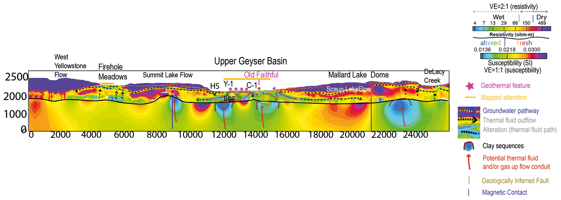
Previously, geologists assumed that deep hydrothermal vents must underlie much of Yellowstone. The new map, however, shows that they exist in discrete areas. “We don’t have the resolution to connect features like Old Faithful with a specific conduit, but we now have the overall picture,” Finn says. “It’s like we can see the city water supply coming into your house but we can’t see the pipes entering your bathroom and kitchen.”
A map with many uses
The map could help park officials avoid areas directly above the hydrothermal system when building new infrastructure. It could also help identify risk sites for one of Yellowstone’s biggest hazards: large hydrothermal explosions caused by sudden releases of pressure. These explosions throw water, steam and rocks into the air, and events large enough to leave 100-m wide craters are expected every few hundred years.
A further use relates to energy production. When similar hydrothermal sites such as New Zealand’s Taupo volcanic zone were tapped for geothermal energy, the behaviour of surface geysers changed – sometimes significantly. Although Yellowstone National Park itself is off-limits to energy companies, the surrounding area does host a few geothermal projects. This map will help geophysicists understand how regional heat sources are connected, and thereby avoid disrupting a US national treasure.
Having an unprecedented view of the subsurface could also help bioscientists identify hot springs with interesting geochemical and biological properties. Yellowstone’s waters can be acidic or alkaline, and are known to harbour a rich variety of bacteria and archaea.
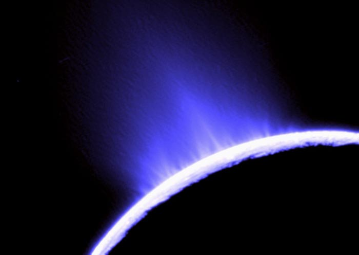
Tides control the geysers of Enceladus
“Given that early Earth was volcanically more active than the present day, developing a more concrete understanding of how geology supports biology in hydrothermal systems like Yellowstone is critically important to understand the processes that led to the emergence of life,” says Eric Boyd, a microbiologist at Montana State University who was not involved in the study. Indeed, organisms in Yellowstone’s hydrogen-enriched hot springs might be the ancestors of primordial life that relied on chemical forms of energy.
Such research could guide our search for signs of life beyond Earth, perhaps in the known geysers on moons of Jupiter, Saturn, Uranus and Neptune. Boyd says that Yellowstone’s most productive hydrothermal ecosystems are sourced by fluids in chemical disequilibrium. Space missions could search for subsurface features that might give rise to similar conditions.