More than three decades after the world’s worst nuclear disaster at Chernobyl, Peter Martin and Tom Scott visit the exclusion zone surrounding the plant to map radiation levels using new drone-based technology
It’s April 2019 and a group of us from the University of Bristol, UK, are being driven though the exclusion zone surrounding the Chernobyl Nuclear Power Plant (ChNPP) in a minibus laden with all manner of radiation detectors, drones and protective equipment. Despite being only two hours north of Kiev, our surroundings could not be more different from the bustle of the Ukrainian capital. The densely vegetated landscape is intersected only by pothole-riddled multi-lane highways – a throwback to more prosperous times when more than just the occasional scientific group or tourist party would make the trip.
As our local driver swerves the bus from one side of the road to the other, it becomes increasingly apparent how different this nuclear fallout zone is from the one surrounding Japan’s Fukushima Daiichi Nuclear Power Plant, which we’ve visited extensively since the accident there in 2011. While the Japanese authorities have been steadily lifting evacuation orders from Fukushima’s original exclusion zone, the area around the ChNPP remains, for the most part, abandoned, and nature is taking over.
During the aftermath of the accident at Chernobyl in April 1986, some 49,000 people were evacuated from the nearby city of Pripyat (3 km from the plant) to various villages in the Kiev region – although this evacuation only began 36 hours after the explosion. Over the following 10 days, the exclusion zone was progressively expanded to a radius of 30 km from the site, and during the subsequent months a further 67,000 people were eventually evacuated from their homes. Indeed, it is believed that some 200,000 were relocated as a result of the accident.
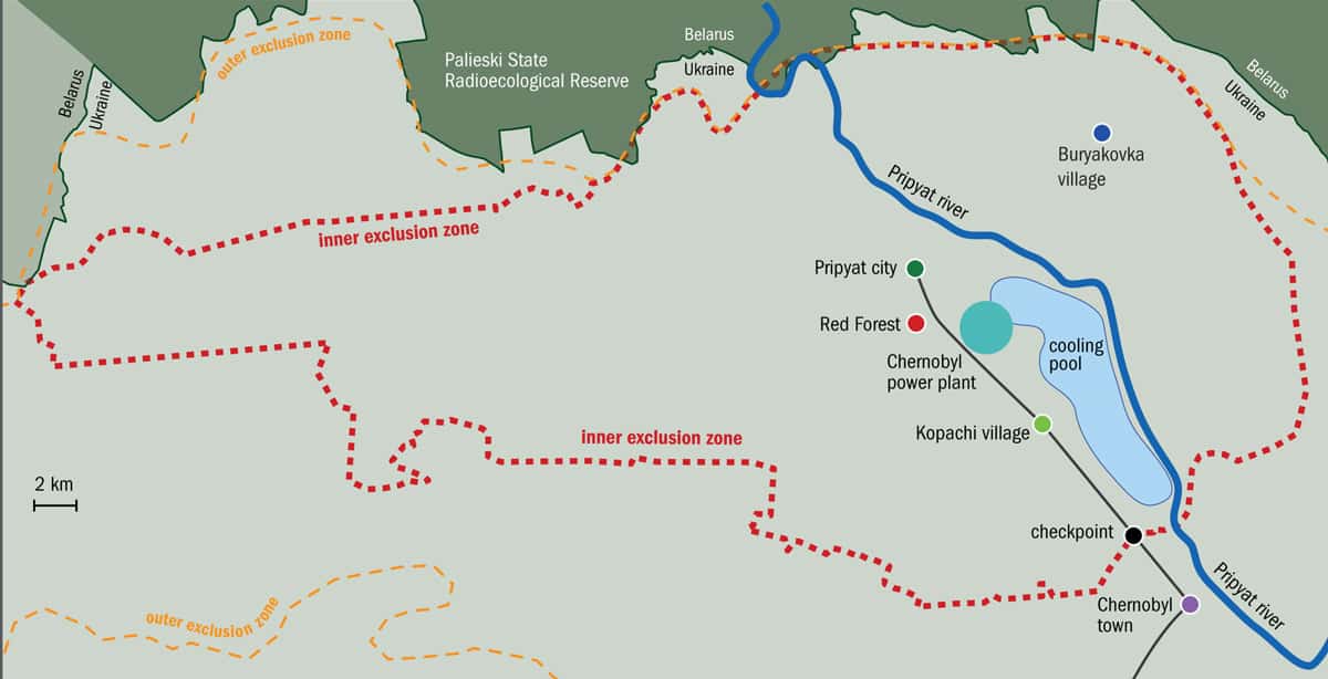
Today, the exclusion zone still forms an area of about 2600 km2 in Ukraine. Although more than three decades have passed since the accident, there are very few residents of the area (termed Samosely – those who either refused to evacuate or secretly returned). Indeed, in 2016 it was estimated that the total population was fewer than 200 people.
Since the accident at ChNPP’s number 4 nuclear reactor, much work has been done to protect its remains and prevent further radioactivity from being released into the environment. The latest effort becomes obvious as we approach the ghost city of Pripyat along the Soviet-era road and the imposing sight of the New Safe Confinement shelter dominates the horizon. Following the deterioration of the original confinement structure that was hastily erected over the exposed reactor core shortly after the disaster, this new dome-like building was completed in 2018 by an international team of engineers, and will provide a cover that should last for at least a century.
The eerie, unmoving silence of the surrounding exclusion zone amplifies our team’s amazement at this incredible engineering achievement piercing through the dense trees. The silence is short-lived, however, as the high-pitched dose-rate alarm of one of the personal dosimeters suddenly sounds. With the alarm threshold still set to identify a slight deviation above normal background radioactivity back in Bristol, it becomes further apparent quite how radioactive parts of this area still remain, even after 33 years. In Bristol we would expect 1–2 counts per second (or CPS) on our radiation detectors – here in Chernobyl we’re measuring more than 50 CPS.
The reactor and accident
One reason for the 1986 disaster was that the country then lacked a fundamental safety culture and competency when it came to nuclear power production. But the poor and unforgiving reactor design did not help either. The four reactors at Chernobyl were RBMKs (Reaktor Bolshoy Moshchnosty Kanalny) – a design that was, and still is, unique to countries that were part of the former Soviet Union.
Like Magnox and the Advanced Gas Reactor (AGR) types in the UK, an RBMK has a large graphite core that houses the reactor’s fuel elements in cylindrical channels, and acts as a neutron moderator (it slows the neutrons produced in a nuclear fission, to sustain the chain reaction). Unlike the two UK designs, however, an RBMK does not use carbon dioxide as the coolant – it uses water. When combined with other features of a Soviet-era RBMK, such as the poor design and insertion mechanism of the control rods, this significantly affects the reactor’s operational safety.
In an RBMK, electrical pumps bring the water in to cool the fuel rods. The heat from the nuclear reactions transforms the water to steam, which then turns the turbine generators, producing electricity. Crucially, however, the water pumps at Chernobyl were run on electricity from the national grid, so, in case of an electrical outage, a back-up diesel-run power supply was available to keep the pumps going and the fuel cool. Unfortunately, these generators took around a minute to power up when needed – a gap that could be enough to cause the reactor to overheat.
Having identified this as a problem, the crew at Chernobyl had been trying to develop a way to power the pumps with the turbine generators during that minute gap. However, tests had revealed that, without water coming in and producing steam, the turbines ran down too rapidly to keep an adequate water flow rate.
It was during the fourth such test, with the reactor shut down, that the accident occurred.
After turning off several safety features over many hours and following other logistical delays, the reactor was shut down – meaning its power output was reduced and stabilized – and the test began in the early hours of Saturday 26 April 1986. The turbines’ stop valves were closed so steam no longer turned them, and the water pumps powered by the slowing turbines started to run down. However, the reduced flow of water – alongside design flaws, human errors and the safety systems being intentionally disabled – made the water at the base of the reactor boil, triggering a catastrophic runaway increase in the reactor’s power. The final known reactor output was around 30,000 MW – 10 times its normal operational value – but it is thought it likely spiked at a further 10 times higher than that.
Two explosions occurred, ejecting fuel, moderator and structural materials from the reactor; starting fires and exposing the core to the atmosphere. Large volumes of radioactive material were dispersed into the environment, spreading far. Although only two workers were immediately killed by the explosions, more than 130 firefighters were soon hospitalized, with 28 dying of acute radiation sickness and a further 14 suffering from terminal radiation-induced cancers in the subsequent years. The total number of Chernobyl-related deaths is a matter of much controversy, with estimates ranging from 4000 to 60,000.
The radioactive aftermath
Radioactivity from Chernobyl was detected around the globe, but most was deposited on or close to the site, with the area to the west of the reactor becoming extremely contaminated. It was this high level of radiation that was responsible for the red colouration, and eventual death, of the pine trees within the 10 km2 of woodland surrounding the plant – this later became known as the “Red Forest”. The area remains one of the most contaminated in the world, even though the trees were eventually bulldozed and buried by “liquidators”.
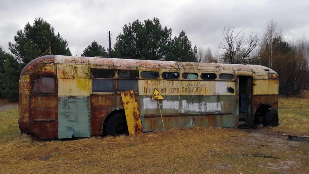
Those who remember the news coverage from 1986 will recall the grainy footage of teams of these liquidators, wearing grey lead aprons and gas masks. They performed crucial tasks in the highly radioactive environment to stop the ongoing effects of the accident from worsening, such as collecting burning graphite and performing initial assessments of the damage. In the months after the accident, these civil and military personnel (some 600,000 of them) also worked to demolish the numerous highly contaminated buildings and bury the debris – as well as other high-activity wastes associated with the accident – in hastily dug trenches. Their work meant that the liquidators were exposed to high levels of radiation, leading to many suffering from disabilities and radiation-caused cancers (the precise numbers are often debated).
In contrast to the technology that exists today, the radiation monitoring following the accident was limited. To obtain a crude initial map of the distribution, intensity and composition of the radiation, people were sent out to take physical measurements around the area using small handheld units. It has since been shown that these were not capable of measuring the high levels of radiation that were released. Measurements were made using helicopters equipped with radiation detectors, but with environmental changes, even the most complete and accurate of these maps are now out of date.
Send in the drones
One thing that is clear though is that Chernobyl is still one of the most radiologically contaminated regions on the planet – and as you would expect, gaining access was not a quick procedure. Ahead of our trip, it took about four months to secure permission to fly unmanned aerial vehicles (UAVs or drones) from the head of the exclusion zone and the authorities running the plant today. And by the time the final permissions were granted, we only had a week before we were scheduled to be at the Chernobyl EcoCentre – which monitors the zone – in the town of Chernobyl.
Here, we were each given radiation-dose-measuring film badges to wear during our time working in the zone and were then taken by our guide to enter the inner exclusion area. The checkpoint that we passed through typified the Ukrainian attitude to the security of the zone, with armed guards closely checking all permission cards and IDs upon entry, and screening people and vehicles for radioactivity when exiting. More used to holiday makers taking part in “nuclear tourism” across the zone, the daily arrival and departure of a team of scientists and their extensive array of flying machines was always met with heightened scrutiny by the guard force. This militaristic façade was, however, softened somewhat by the dogs that are cared for by the security personnel – descendants of those left behind by past residents.

Our team and the Ukrainian authorities both wanted to see if we could deploy a technology capable of mapping large and potentially inaccessible areas of the exclusion zone at greater resolutions than before, to determine the location and level of the residual contamination. While total decontamination and repopulation are never likely to occur in Chernobyl (unlike around Fukushima), the land is currently being considered for solar energy farms. Although this may at first sound a little unusual, the repurposing of land that has no other use or value – but utilizes the existing power distribution network that dissects the region – would contribute much-needed wealth to the local and national economies.
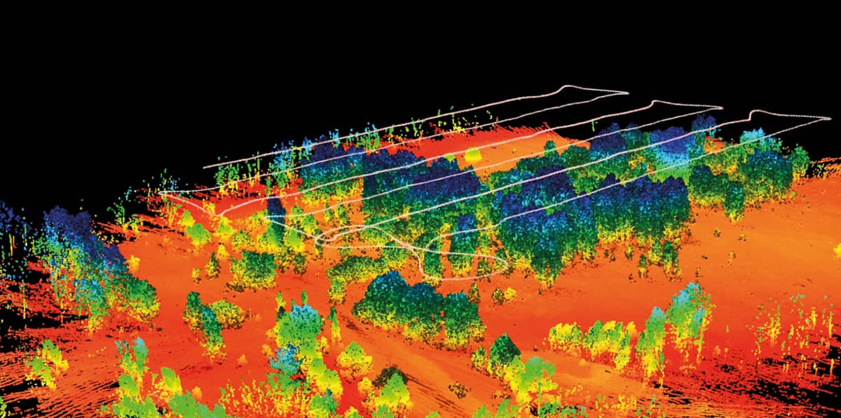
To survey the areas of interest, we were building on our team’s work of using multi-rotor UAVs for radiation mapping by developing a bridge between high-altitude (200–500 m) manned helicopters and low-altitude (<20 m) UAVs. Our fixed-wing drone aircraft can cover tens of kilometres while flying at an altitude of 45–100 m. Housed securely within the fuselage of the plane – which has a span of about 2 m – is a complex array of flight-control electronics, sensors, solenoids and highly sensitive radiation detectors that measure the energy of the gamma rays they intercept as the plane flies its survey route. The radiation detectors we used were caesium iodide scintillators that weigh only 150 g. These lightweight detectors are made by a UK company called Kromek that specializes in miniaturized gamma-ray detectors.
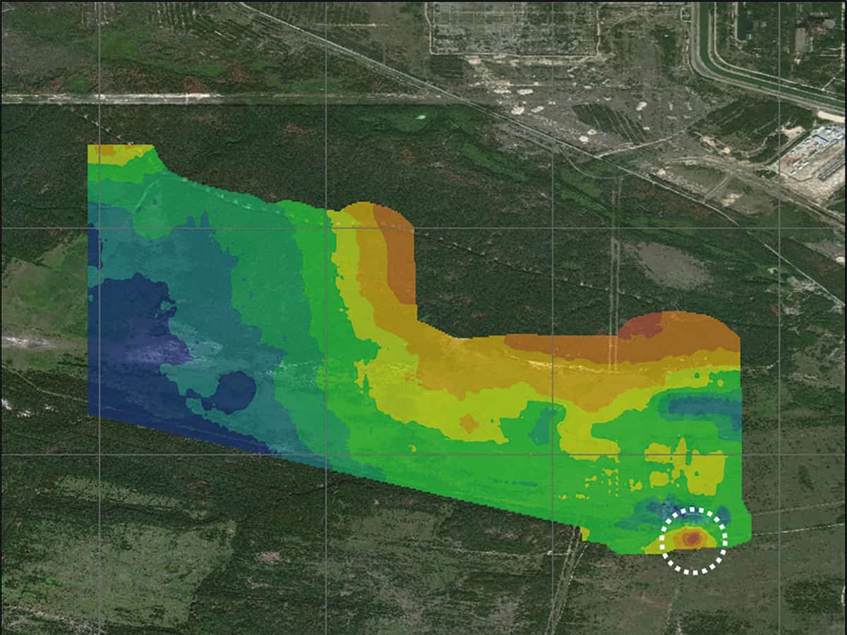
One of the contaminated sites where we deployed both the fixed-wing plane and the multi-rotor drone was a small industrial repair and scrap yard in the village of Kopachi, 2 km south of the plant. Unlike the fully automated take-off, surveying and landing that can be done by the multi-rotor UAV, the logistics and preparations for surveying with the lightweight plane are more extensive. As the plane needs lots of speed to get it airborne, it has to be physically propelled into the air by hand – literally thrown while at full power – in an open space. Once safely in the air, the plane can survey autonomously along its pre-set flightpath for up to an hour before returning home and using its parachute to gently drop down to earth.
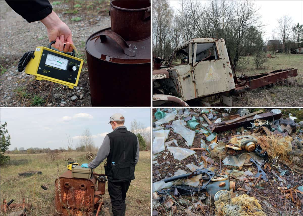
As we expected, the radiation levels are considerably higher than in the area surrounding most of the Fukushima plant. While the contamination is generally uniformly distributed, the sensitive detectors on our fixed-wing plane made it possible to locate regions with very high levels of radioactivity (up to 350 μSv/hr) – some of which were previously unknown to the authorities. After we had determined the area of interest with this higher-altitude platform, we then sent in the multi-rotor UAV. By surveying at lower altitudes and applying our algorithms to both sets of results, we were able to work out exactly where any on-the-ground radiation “hot spots” were located. At the Kopachi site, these isolated areas were found to be related to the accident response, such as where vehicles had been abandoned, buried or washed, with rain and ground water depositing the highly radioactive particulate around the area.
However, the most radioactive location in Kopachi is a bowl-shaped area containing three large metal hoppers, where bulk rock and sediments containing a component of radioactive material have been separated – with the radioactive material left in situ. While other sites are dominated by the gamma-ray emissions from fission products, the bowl-shaped site exhibits a spectrum that indicatives the presence of fuel waste. Needless to say, we didn’t hang around in the area as the dose-rate was equivalent to receiving your entire annual UK background dose (2.7 mSv) in just one hour.
The future of Chernobyl
Having visited Fukushima many times, our trip to Chernobyl truly emphasized the much greater scale of the accident there. The occurrence of areas with extreme radioactivity after three decades highlights the challenge that the Ukrainian authorities face, and shows why this is one of the most difficult and dangerous environments on Earth. We hope to return to Chernobyl soon to work alongside colleagues at the EcoCentre and continue deploying our aerial radiation-mapping systems and location algorithms.
The occurrence of areas with extreme radioactivity after three decades highlights the challenge that the Ukrainian authorities face, and shows why this is one of the most difficult and dangerous environments on Earth
With the Ukrainian authorities planning to transform large areas of the exclusion zone into solar-energy farms, there is a critical need to understand the exact location of harmful levels of radioactive contamination, without requiring individuals to enter these regions to take measurements. Equally, for areas frequented by tourists, it is important that the local authorities and guides have detailed maps of the residual radiation to delineate where to avoid. Although more research is still needed to improve our software algorithms as well as further enhancing flight performance, our systems could make a real difference in the months and years to come in helping transform the contaminated and lonely Chernobyl exclusion zone.