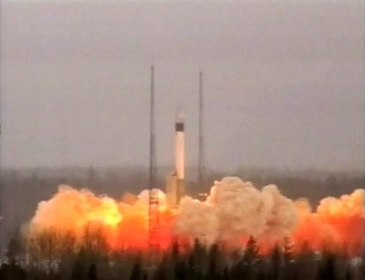
A mission to make a very high-resolution map of the Earth’s gravitational field has blasted off today at 15:21 local time from the Northern Russian Plesetsk Cosmodrome. The €350m Gravity Field and Steady-State Ocean Circulation Explorer (GOCE) will produce a much improved model of the “geoid” — the gravitationally-defined surface that Carl Friedrich Gauss described as the “mathematical figure of the Earth”. GOCE, launched by the European Space Agency, will fly at an altitude of just 250 km and operate for 20 months.
The gravitational force at the Earth’s surface, g, does not have a constant value but varies across the planet. The most significant variation is due to the Earth’s spin, which causes it to bulge very slightly at the equator, meaning that the surface at this point is further from the planet’s centre – by about 20 km – than it is at the poles. Due to this – and also to an unequal distribution of mass inside the Earth – g is 9.83 m s–2 at the poles but only 9.78 m s–2 at the equator. Other, more minor, influences cause smaller variations in g – for example, mountains and ocean trenches lead to fluctuations at the third decimal place.
Associated with these fluctuations in g is a representation of the Earth’s surface known as the geoid. This is defined as the surface of equal gravitational potential and follows the surface of the ocean without any tides and is the basic ellipsoid shape of the Earth but with very smooth, shallow bumps and depressions superimposed on top of it, according to the local variations in gravity. For example, the extra mass in a mountain 2 km in height under the sea attracts water over it to produce a bulge in the sea surface some 2 m high and 40 km across.
Plotting the variations in g itself could allow scientists to improve their understanding of geophysical processes, such as earthquakes. Mapping the geoid, on the other hand, provides a base reference – or 0 m sea level – throughout the world and lead to a better understanding of ocean circulation, and hence climate. This is because local values of the geoid can be subtracted from radar measurements of the sea level to reveal the heights of waves around the world, and this surface behaviour can then be combined with data on the topography of the sea bed to calculate currents and heat flows through the oceans.
To measure gravitational fluctuations over large distance scales, but at low resolution, GOCE will continuously record how its orbit changes – and therefore how its pull towards the Earth changes – with respect to GPS satellites. To fill in the details of fluctuations over smaller scales, GOCE will sense the minute differences in acceleration experienced by three pairs of proof masses held at the ends of arms 50 cm long inside the spacecraft. In this way, the mission should measure g to an accuracy of 10–5 ms–2 and of the geoid to an accuracy of 1–2 cm, with both sets of measurements plotted with a resolution better than 100 km.
GOCE’s resolution will be far better than earlier gravity-measuring satellites, such as the US–German GRACE mission, launched in 2002, that was limited to a resolution of 600 km. GOCE mission manager Rune Floberghagen says that although GRACE can record changes in the Earth’s gravitational field over time, allowing it to observe the melting of polar ice caps for example, its lower resolution means that it cannot study ocean circulation in great detail, as GOCE can. “The GRACE mission delivers low-resolution movies of gravity-field variations,” says Floberghagen, “while GOCE will deliver an ultrahigh-resolution snapshot.”


