On 16 December 1920 at about 7 p.m. local time, a magnitude-7.9 earthquake ripped along 240 km of fault in north-central China, razing two cities to the ground and severely damaging five others. It was one of the most devastating earthquakes ever seen and around 230,000 people died. Today, on the centenary of the Haiyuan quake – known colloquially as “the mountains walked” – researchers at the American Geophysical Union (AGU) Fall meeting are discussing how to better prepare for the next “big one”.
One of the reasons that the quake was so deadly is because it took people by surprise: the last major earthquake on this fault occurred over 1000 years earlier. Long periods of inactivity are a common feature of earthquakes on continental plates and in the intervening years cities are unwittingly built right over the hidden fault. Large swathes of the world, including regions from the European Alps to the Himalayas and much of the US, are prone to continental quakes. Luckily, continental faults tend to be easier to study than oceanic ones. “Unlike off-shore faults, which are very difficult to access, it is possible to set up geophysical sensors along continental faults and dig trenches on the surface to understand their long-term behaviours,” says Zhigang Peng from Georgia Institute of Technology in Atlanta, who has organized the AGU Haiyuan quake session.
In recent decades sophisticated Earth surveillance techniques including satellite and drone imagery, LiDAR scans and GPS measurements have enabled researchers to pick up on early signs of continental fidgeting. For example, Wenqian Yao, from the China Earthquake Administration, and colleagues have used unmanned aerial vehicles to survey the landscape along the Haiyuan fault system. Combined with measurements of slip rate on the ground they have discovered that strain is building on an offshoot of the Haiyuan fault, known as the Zihong Shan fault. Their findings suggest that the Zihong Shan fault could produce a quake of up to magnitude-7.
Today scientists are making long-term seismic hazard maps in many countries
Zhigang Peng
Similarly, Yacine Nicolas Benjelloun and colleagues from Institut de Physique du Globe de Paris have used drone images to map two major continental faults in Northwestern Mongolia, known to have produced a magnitude eight quake in 1905. Combining the drone data with geological history of fault movement has enabled them to estimate the seismic hazard for this region – an approach that they believe could be applied anywhere.
James Neely and Seth Stein from Northwestern University, meanwhile, have used the last 40 years’ worth of quake data to categorize continental earthquakes all over the world. Using this information they have been able to divide continental quakes into four categories and show that normal faults – where the crust is being stretched apart – have a maximum magnitude of seven, while other continental fault geometries can reach magnitude eight. For engineers, this kind of information is vital as designing buildings and infrastructure to withstand a magnitude eight is significantly more complex and expensive than for a magnitude seven (which is 10 times smaller than a magnitude eight).
Fault lines
Despite all the technology available to us today, researchers remain humble towards continental quakes. Some faults accumulate strain so slowly that they are invisible to modern instruments right up until the moment they move. The 1994 Northridge quake in California was an example of this, with no-one having any idea that this suburb of Los Angeles sat atop a major earthquake fault. And even when researchers identified a fault they don’t know how much strain will make it pop, or how the fault will move. “We don’t know if an earthquake is going to grow large and rupture several faults, or stay small and confined to a single fault,” says Neely. How to forecast an earthquake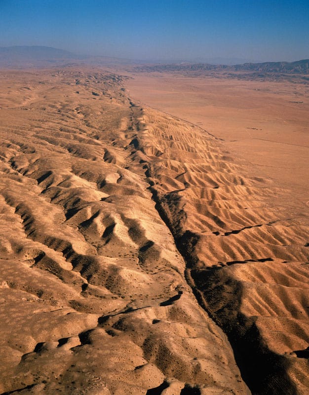
As a result, the main focus of research today is to estimate the seismic hazard of a region and make preparations. For example, a report submitted to the German Federal Parliament in November outlines the chance of a major earthquake near the city of Cologne and makes recommendations for mitigating such an event. The findings shows that this region should expect a quake with a magnitude of 6.5 every 1000 to 3000 years. If such a quake occurred tomorrow the researchers estimate that around 10,000 buildings would suffer moderate to severe damage and somewhere between 100 and 1000 people would die.
As the 2008 Sichuan quake in China and the 2010 quake in Haiti demonstrate, we still have a long way to go when it comes to protecting ourselves from continental quakes. But Peng and his colleagues think that significant progress has been made. “In the 1920s, the concept of an active fault within continents was very new,” he says. “Today scientists are making long-term seismic hazard maps in many countries.” Peng adds that buildings are also generally much stronger than one century ago and people are “generally more aware and know how to stay safe during these events”.