A year after a devastating earthquake hit Mexico City, Lucina Melesio examines how the development of early-warning smartphone apps could help save lives in the future
On 19 September 1985 Mexico City was reduced to rubble by a magnitude-8.0 earthquake. While the epicentre was more than 370 km from the city, about 10,000 people died, with 3000 buildings damaged of which 400 collapsed. It was one of the worst tragedies in the metropolis’s 700-year history. To commemorate the disaster, as well as raise awareness of the danger of earthquakes, the city now holds drills on that same day every year.
In 2017, however, that year’s drill quickly turned into a real event when two hours later a 7.1-magnitude earthquake struck the city without warning. Mexico City resident Alejandra Castillo recalls the shock when the ground began to shake violently beneath her. “I remember everyone was screaming and we were all trying to reach the safety zones,” she told Physics World. “I couldn’t make it because the movement was too intense, so a colleague dragged me.”
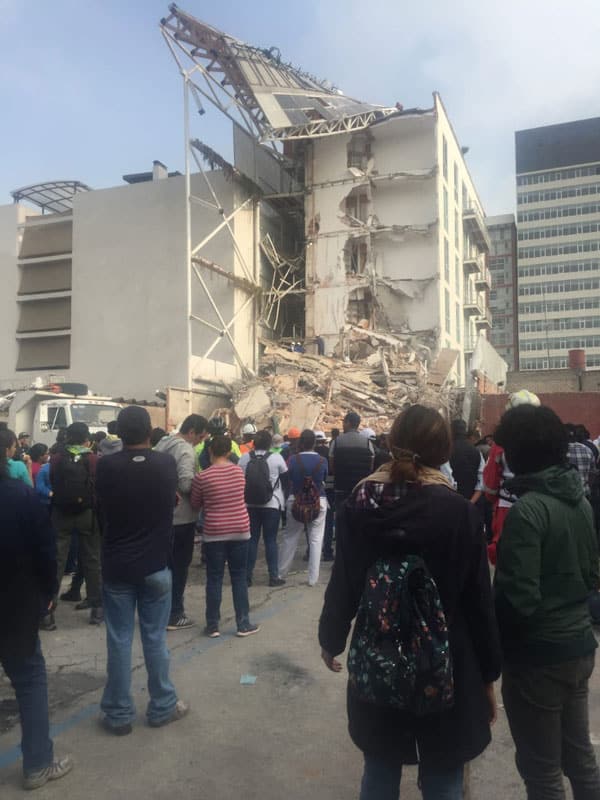
When Castillo returned home, her apartment, which she had just purchased six months earlier, was no longer there. The entire five-storey tower block had collapsed with volunteers still desperately searching for two women trapped inside. “When my husband arrived, we held each other in silence,” she says, adding that all they had left were the clothes they were wearing that day. The earthquake – dubbed 19S – killed 228 people in Mexico City, damaging almost 6000 buildings with more than 40 collapsing.
This was the second big earthquake to hit Mexico that month. At 11.50 p.m. on 7 September 2017 – just 12 days before 19S – Mexico City was awoken to 12,000 loudspeakers warning of an incoming quake. People had two minutes to exit buildings and find safe spots to wait. While the 8.2-magnitude earthquake had devastating effects in the southern states, Mexico City was unharmed.
Getting the message out
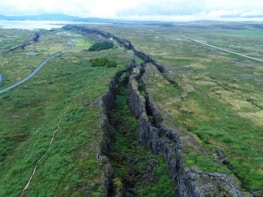
Back in 1985, the only early quake-detection system in the world was in Japan, solely introduced so that engineers could stop the country’s high-speed bullet trains before they potentially derailed. But a team of engineers in Mexico realized there was a huge difference between earthquakes in Japan and those in Mexico City. The former occur mainly right underneath the city, whereas the latter mostly occur off Mexico’s coastline, which is hundreds of kilometres away. Mexico City is also particularly vulnerable to earthquakes because the city is built over an ancient lakebed so that the ground amplifies the effects.
Seismic primary waves (P-waves) are the fastest type that are produced by earthquakes and since they are basically sound waves their speed is limited by that of sound. This means that, in principle, once a quake is detected, it is possible to send an alert (via radio waves) faster than the quake approaches. The distance from the quake’s epicentre determines not only the intensity at which it hits locally, but also how much time in advance the alarm can alert people about it.
This was the idea that inspired engineer Juan Manuel Espinosa and his team in the late-1980s to start the Mexican Seismic Alert System (SASMEX) – the very first automated public earthquake alert system in the world. He developed an algorithm to identify quakes from other types of vibrations and installed earthquake sensors along the coastlines of Mexico. If a quake exceeded magnitude five, the system would issue an alert and people would be able to find safe spots in advance, sometimes up to two minutes in advance.
SASMEX is operated with government funding but is owned by Espinosa’s non-profit company CIRES, which develops seismic instrumentation. The system has been working since 1991 and today it interrupts public TV and radio broadcasts to transmit the alarm, while 12,000 speakers relay the news across the city. According to Espinosa, the system now has 97 seismic sensors, mostly distributed along the coastlines where most strong earthquakes are expected to start.
Why the supposedly weaker second quake in 2017 caused so much devastation is due to the make-up of the tectonic plates. Mexico is located over three large tectonic plates, with the country being one of the world’s most seismically active regions. Usually earthquakes in Mexico are caused by the collision of the North American plate with the Cocos plate in the Pacific Ocean, so epicentres are near the coastlines.
This system works well for earthquakes that arise along the coastlines because most of the sensors are located there. Indeed, the epicentre of the earthquake on 7 September was 650 km away from Mexico City in the Gulf of Tehuantepec off the southern coast of Mexico, near the state of Chiapas. 19S, however, was different. It occurred inland within a plate itself and with a epicentre only 120 km away from Mexico City. According to witnesses and local media, the alarm went off only after the impact of 19S was felt in Mexico City.
Espinosa told Physics World that the reason for this was because the epicentre was too close to Mexico City. Espinosa adds that the algorithm they were still testing in that region was not fast enough to send the signal on time before the earthquake. “We’re working on improving our algorithms to make them faster,” says Espinosa, adding that other developments will include extending their network of seismic sensors by 60 to include the state of Chiapas and other regions, as well as developing graphic alerts for people with hearing impairments.
Blazing the trail
Having SASMEX government-funded but not publicly managed has inconveniences. In February 2018 SASMEX suspended its service in Oaxaca, a southern state on Mexico’s coastline that was severely affected by the earthquakes in September 2017, because the government had overdue payments for using the service. Having a state without service affects other cities – including Mexico City – because quakes often strike along Oaxaca’s coastlines.
Given such disadvantages, entrepreneurs are sensing an opportunity. Founded in 2011, SkyAlert is perhaps the most popular earthquake-alerting start-up. The Mexican firm offers a free app that warns users of an incoming quake as well as the local intensity in six different levels ranging from weak to severe. For a subscription of £3.70 per year, it offers a filter so that users only receive alerts relevant to their location.
Álvaro Velasco, SkyAlert’s co-founder and chief technology officer, told Physics World that the number of subscribers doubled after 19S to seven million. He says that recent investment has allowed the firm to expand its network of seismic sensors to 120. These span from Chiapas to the western state of Jalisco – more than 20% larger than SASMEX’s network – and covering 80% of the quake-vulnerable population. “We’re working on changing the algorithm to let people know how much time they have before the quake reaches their location,” says Velasco.
Richard Allen, a seismologist at the University of California, Berkeley, has spent 10 years developing a similar system for the US. Called ShakeAlert, it uses sensors that have been built by the US Geological Survey but has a different algorithm to the Mexican version as earthquakes affecting California have their epicentres right next to the cities. “Mexico really was the first place to do public earthquake early warnings – so Mexico should get all the glory for blazing the trail – and here in the US we are continuing to learn from that system,” Allen told Physics World.
Damage assessment
Mario Ordaz, an engineer at the National Autonomous University of Mexico (UNAM), has been providing seismic-risk assessment services for over 25 years. In 2005 he developed an automated system that, within 10 minutes of an earthquake, delivers Mexico City’s Civil Protection Agency an early damage assessment map so that authorities know where to send aid immediately. This provides information such as local seismic intensities, probable building damage, an estimate of human casualties and possible water-supply interruptions.
It is a one-of-a-kind system that works even if power and communications are down. But Ordaz says Civil Protection – despite being the commissioning agency– has dismantled their reception network and they are not even aware of the system anymore. “The only sector that has truly been interested in these developments, hasn’t been the government or Civil Protection, but rather the insurance industry,” says Ordaz. Civil Protection did not respond to Physics World’s request for comment.
Ordaz’s detailed seismic-loss estimation models have been used by the insurance industry since the 1990s, even setting their natural hazard guidelines. “Many of these developments have been paid by the insurance industry, and since 1998 the National Insurance Commission has used a model we developed, building by building all over the country, to measure risk against their clients, and with that info determine how many reserves they need to insure their clients,” says Ordaz. “It’s pioneering regulation in the world that demands insurance companies have enough money to provide coverage based on real risk estimates.”
A simple version of his model is available through a free app, called quakeRisk. After choosing any given historical earthquake through a database, users input GPS location, type of building, age of construction, number or storeys and a few other parameters, to obtain “risk of loss” for that particular earthquake. Ordaz explains that the technology behind the app can be used for any given purpose, for example, owners checking their construction blueprints against an earthquake. “It could have been complicated to do this assessment for the entire city, but the technology’s been there, so maybe if we had started this in 1985 we would have already finished by now,” adds Ordaz.
Mexico has many systems in place to prevent buildings from collapsing but most of the new buildings that suffered damage did not comply with construction regulations
Even so, in 2004 building regulations in Mexico City were updated to issue specific guidelines for buildings in six different zones divided by ground conditions, adding additional guidelines in the annexes with an even finer mesh. UNAM’s Engineering Institute has a vibratory table where construction companies can test their structures to different quake stresses before starting construction. Mexico has many systems in place to prevent buildings from collapsing but most of the new buildings that suffered damage did not comply with construction regulations. Having all these systems in place does not mean much without law compliance and enforcement.
City strategy
Most people who lost their homes in 2017 are still waiting for reconstruction funds. Only 4.7% of the £467m reconstruction fund for Mexico City has been accounted for, according to the non-profit firms NGO Nosotrxs and Mexico’s Network for Public Accountability (RRC). Liliana Veloz, RRC’s executive director, says that she believes that while Mexico’s emergency response is solid, there are no real strategies in place when it comes to dealing with reconstruction and accountability.
“Mexico simply doesn’t have short- and medium-term strategies to prevent this from happening again,” says Veloz, pointing out that there are buildings that were damaged back in 1985 that are still occupied and people still homeless after all these years. “We’ve seen that even with the current law, if it was enforced, things would work a lot better,” she adds. “What Mexico really needs is to establish controls to ensure law-compliance.”
What happened with Castillo’s building should never have happened. No-one has been held legally responsible for the deaths and damages caused, even though forensic analysis determined the building collapsed because it did not comply with construction regulations. Castillo is now back to being a tenant and hopes justice will serve her soon. “I used to feel angry, but now, I can’t understand how some housing developers can walk around knowing they could be responsible,” she says. “I feel rather disgusted.”