Space agencies are playing an increasing role in the race to understand the global spread of COVID-19. Satellite data are being used to explore links between pollution and COVID-19, while land-use tracking over the longer term might help to understand how pandemics emerge. These developments were discussed at the European Geosciences Union’s annual meeting, which took place online this week.
Medics across the globe have noted that underlying health issues play a significant role in mortality rates among COVID-19 patients. In the past few years, a growing body of research has established that exposure to fine particulate matter (PM2.5) – such as the nitrogen oxides common in air pollution – can lead to health issues, particularly heart and lung problems.
Provisional studies in the US, Italy and England have all found tentative correlations between regions of higher pollution and raised mortality rates among COVID-19 patients. Right now, the tricky bit in these studies is trying to rule out all the confounding factors, such the fact that pollution hotspots tend to overlap with densely populated areas.
At the same time, there is also an active debate about the length of time that SARS-CoV-2 – virus responsible for COVID-19 disease – can remain suspended in the air by aerosols.
Tracking pollution
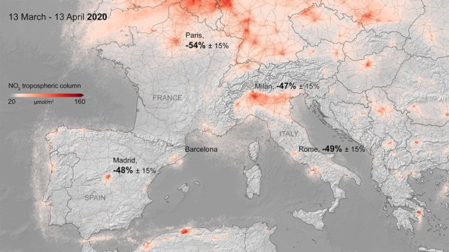
Recognizing the pressing need for further research, the European Space Agency (ESA) has created a dedicated resource frequently updated with maps and data. For tracking nitrogen oxide levels, the key satellite is Sentinel 5P – part of the fleet of the European Union’s Copernicus Earth-observation programme.
“I have asked my teams to quickly put together activities where Earth-observation data can help in the coronavirus health crisis,” said Josef Aschbacher, director of ESA’s Earth-observation programmes. “We are doing this very closely with our partners in the European Commission but also with NASA and the Japanese Aerospace Exploration Agency [JAXA].”
Space agencies are also looking to support novel ideas for using Earth observation data in the COVID-19 crisis and the period of adaptation that will follow. ESA has launched a Euro Data Cube contest requesting for ideas relating to economic activity, agricultural activity, and other human activity distributions.
NASA has invited researchers within several of its science divisions to refocus on the COVID-19 pandemic, and they will be providing an additional $2 million for new satellite-related data projects. NASA has also teamed up with ESA and JAXA to run a special versions of its Space Apps Challenge on 30–31 May – a virtual hackathon focused on the COVID-19 crisis.
Pandemics becoming more likely?
Aschbacher believes that Earth observation can also play a role in understanding the origins of COVID-19 and the likelihood of future pandemics. He pointed out the scientific consensus is that COVID-19 most likely originated in an animal, probably a bat, which passed it to a larger mammal. A recent study by researchers in the US and Australia concluded that deforestation and urbanization are increasing the likelihood of diseases jumping from animals to humans. Tracking deforestation and other land-use changes could assist with future studies.
This view that the Earth system is dangerously out of balance is also shared by Silvia Peppoloni, secretary general of the International Association for Promoting Geoethics. “The growing impact of human activities on bio-geological systems, if not properly controlled in accordance with the transitory ecological balances, produces an increased pandemics risk,” she said. “COVID-19 is the effect of this non-functional, unhealthy, dangerous interaction for humanity.”
To help geoscientists engage with these types of complex interconnected questions, ESA is launching a new initiative called Digital Twin Earth. The idea is to bridge the gap between data collected by satellites and data recorded at the Earth’s surface. It will provide researchers with a range of tools – incorporating AI and machine learning – for modelling complex environmental scenarios, such as how deforestation in the Amazon impacts the entire Earth system.


