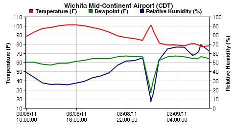
Temperature and humidity graph from Wichita, Kansas (Courtesy: AccuWeather)
By Margaret Harris
I grew up in Kansas, where unusual weather isn’t so much a conversation topic as a spectator sport. But even by Kansas standards, what happened in Wichita (the state’s largest city) last Thursday night was decidedly weird.
As the graph shows, shortly after midnight on 9 June, the temperature in Wichita jumped from 85 to 102 °F (roughly from 30 to 40 °C) in less than 20 minutes. At the same time, the relative humidity plunged, dropping from 55% to a desert-like 7%. Two hours later, both readings had returned to “normal” – or at least, as normal as Kansas weather ever gets.
What happened in Wichita is known as a “heat burst”, and it occurs when a pocket of air in the upper atmosphere collapses, producing a hot, dry downdraft and winds in excess of 60 miles per hour. Such bursts can be seriously damaging: when a meteorologically similar (but colder and wetter) event called a microburst hit a neighbourhood in my hometown back in the late 1990s, it flattened houses as efficiently as any tornado. But how did the air pocket get there in the first place?
The answer (courtesy of this excellent post from John Rennie of The Gleaming Retort blog) turns out to involve one of my favourite weather phenomena: virga, the high-altitude rain that leaves grey streaks across the sky as the moisture evaporates before reaching the ground. This evaporation process pulls heat out of the surrounding air, leaving it colder and denser. If this pocket of air becomes more dense than the air below it, it falls.
But as Rennie notes, that doesn’t explain the heat and low humidity in Wichita’s heat burst. For that, we need some more physics. As a parcel of cold, dense air falls, it becomes even more dense because it gets squeezed by the higher-pressure air present at lower altitudes. This squeezing does work on the parcel, heating it adiabatically. But of course, heating air causes it to expand, and as a result, most potential bursts never hit the ground. Instead, the competing influences of pressure and temperature cancel each other out, the parcels reach an equilibrium at some altitude, and any excess heat is absorbed by the surrounding air. Wet air is particularly good at this, thanks to the high heat capacity of water vapour.
In Wichita, however, the air seems to have been falling too fast to achieve any kind of equilibrium. It was also falling through a relatively dry layer of atmosphere, so there wasn’t much water vapour around to absorb the heat it generated as it fell. The result was the hot, dry “whoosh” shown in the graph.
I should warn you that there are probably some holes in this explanation, since downbursts of all types (wet, cold, hot, dry) are still poorly understood. But the next time you wake up hot and thirsty in the middle of a strange wind storm, relax:it may just be Kansas weather up to its usual tricks.