Losses from the ice sheets of Antarctica and Greenland in the last 16 years have far outpaced snow accumulation, leading to around 14 mm of sea level rise since 2003, a research team led by the University of Washington has revealed. The findings – based on elevation measurements taken by two NASA laser-ranging satellite missions – may help refine our understanding of how ice sheets are reacting to climate change.
Traditionally, studies of the changing mass of ice sheets have relied on combining measurements from various airborne and satellite-based missions, often only representing limited snapshots of time. In the new study, however, researchers contrasted data from NASA’s 2003–2009 ICESat (Ice, Cloud and land Elevation Satellite) mission with its counterpart ICESat-2 that launched in 2018 – allowing for a detailed comparison of elevation changes at tens of millions of sites, from which the team could estimate ice sheet mass changes over the span of more than a decade.
“If you watch a glacier or ice sheet for a month, or a year, you’re not going to learn much about what the climate is doing to it,” says lead author and Washington polar scientist Benjamin Smith. “We now have a 16-year span between ICESat and ICESat-2 and can be much more confident that the changes we’re seeing in the ice have to do with the long-term changes in the climate.”
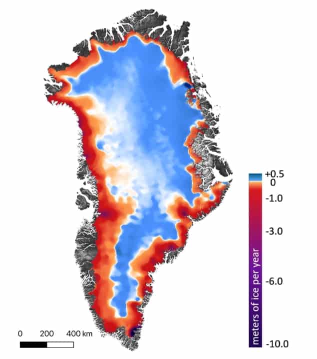
The researchers found that from 2003–2019, Greenland’s ice sheet shed an average of 200 gigatons of ice each year, while Antarctica lost around 118 gigatons. For comparison, one gigaton of ice would fill some 400,000 Olympic swimming pools. Of the resulting sea level rise, two-thirds came from Greenland ice losses.
“It was amazing to see how good the ICESat-2 data looked, right out of the gate,” says NASA’s ICESat-2 project scientist Thomas Neumann. “These first results looking at land ice confirm the consensus from other research groups, but they also let us look at the details of change in individual glaciers and ice shelves at the same time.”

In Greenland, for example, the team found significant ice losses from the thinning of coastal glaciers – such as Kangerlussuaq and Jakobshavn, which both lost between 4–6 m of elevation each year on average. Ice is being lost both from the surface of the glaciers and ice sheets as a product of warmer summer temperatures, but also from their fronts in places due to the presence of warmer ocean water.
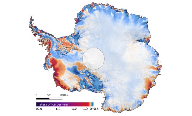
Increased snowfall in Antarctica, meanwhile, appears to be causing a thickening of the ice sheet in the content’s interior – but this is being overwhelmed by melting at the edges of the ice sheet. “In West Antarctica, we’re seeing a lot of glaciers thinning very rapidly,” Smith says. “There are ice shelves at the downstream end of those glaciers, floating on water. Those ice shelves are thinning, letting more ice flow out into the ocean as the warmer water erodes the ice.”
Because the ice shelves are already floating, their loss does not contribute to sea level rise – but such has a knock-on effect. “It’s like an architectural buttress that holds up a cathedral,” explains paper author and glaciologist Helen Amanda Fricker of the University of California, San Diego. “If you take away the ice shelves, or even if you thin them, you’re reducing that buttressing force, so the grounded ice can flow faster.”
In West Antarctica – home to some of the continent’s fastest glaciers – the team found that the Thwaites and Crosson ice shelves are being thinned the most, losing ice at an average of 5 and 3 m each year, respectively.

New satellites set to eye up Earth’s ice and water
“I would say that the overall findings offer an evolution rather than a revolution of our understanding of current trends in ice sheet mass loss,” comments Andrew Sole – a glaciologist from the University of Sheffield who was not involved in the present study – explaining that the ICESat data broadly support other recent ice sheet mass balance assessments. However, he added, the precision of ICESat-2 measurements compared with radar allows for more accurate analysis of the steeper ice sheet margins where much of the recent loss of grounded ice has occurred – and will likely help us better understand the processes driving these trends and the balance between melting ice shelves and the glaciers that feed them
The research is described in Science.


