A career in severe-weather research offers flexibility and plenty of opportunities to experience the fascinating physics of the rotating fluid called the atmosphere. Josh Wurman describes the science of storm-chasing and why hurricanes are scarier than tornadoes

I am standing on a bridge near the North Carolina coast. There is a light breeze, and I am enjoying some hazy sunshine. But this calm is an illusion: in a few minutes winds of up to 45 m s–1 (100 mph) will sweep in again. The approaches to my section of the bridge are already drowned under 2.5 m of water, and my companions on this island are an eclectic mix of traumatized animals, including snakes, rats, wounded pelicans and frogs. Earlier, one of the snakes flew through the air past my truck. The animals and I have been drawn to this bridge by Hurricane Isabel, which has just slammed into the coastal islands of North Carolina, and at the moment we are in the calm, sunny eye of the storm. The animals are just trying to survive on the area’s only dry ground. But I have come to the bridge with a radar system on a truck and have spent a night and a day on it because I want to know what is happening inside this hurricane.
Chasing innovations
Meteorological research is a highly mathematical subject, and I have been intrigued by maths since I was a small child. Once, I spent dozens of hours working out the digits of π using a printing calculator (this was the 1960s) and what I soon realized was a very slowly converging formula. But I also loved being outdoors, so in between my calculations I collected thousands of insects, pinned in boxes and stored in hundreds of pill boxes in my family’s freezer.
As I moved beyond collecting numbers and bugs, I became interested in weather. The study of atmospheric motion is very mathematical, essentially applied fluid dynamics, and the real-world effects of these equations can be seen every day. The equations of motion for the atmosphere cause trees to be blown down, hail to fall and snowdrifts to pile up — all things that I could witness while growing up in Pennsylvania.
I started out as a physics major at the Massachusetts Institute of Technology (MIT), but my real interest was meteorology, in which MIT only had a graduate programme. Fortunately, the university was quite indulgent of me, and I was allowed to combine my physics classes with several graduate meteorology classes to earn a hybrid degree in interdisciplinary science.
While I was finishing my PhD on microbursts at MIT, a “tea hour” discussion with some friends got me thinking about constructing weather radar networks using “passive” rather than the traditional “active” radar sites. Passive radar systems are almost a hundred times cheaper than active systems, which require expensive components like powerful high-voltage transmitters and large antennas. I wrote to the heads of a few research labs and was surprised that they not only read my letters, but even wanted to fly me out to explain my ideas. One of these trips brought me to the National Center for Atmospheric Research (NCAR) in Boulder, Colorado, where I became a visiting scientist in 1991 and began developing and testing my new radar-network concept.
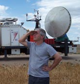
Before too long, however, I became distracted by how little we really knew about what was going on inside severe-weather systems. In the mid-1990s, no one had yet mapped out the winds inside tornadoes, so no one really knew how strong they were. After reading the relevant literature, I decided that a more ambitious technological and logistical approach could push back the veil of ignorance about these fascinating phenomena. So in 1994 I decided to shift focus, leaving NCAR for a faculty position at the University of Oklahoma, where I developed a prototype mobile weather radar system called the Doppler on Wheels (DOW).
A DOW is a cutting-edge Doppler weather radar that is mounted on a truck. The concept is simple. Instead of waiting for interesting weather to come to me, I drive to the weather (like Hurricane Isabel) and surround it with DOWs and other instruments. In its first few weeks of testing, the DOW made important new measurements inside tornadoes, which allowed my team to produce the first-ever 3D mapping of tornadic winds. With new data coming in every minute, we could watch the wind, debris and rain fields evolve in something close to real time.
Since 1995 the DOW and its descendents have observed and mapped the wind fields of more than 140 tornadoes. These include the most intense tornado ever documented, which hit Moore, Oklahoma, in 1999 with near-surface winds of 142 m s–1; and the two largest tornadoes ever mapped, one of which occurred in the same 1999 outbreak and had a core circulation that was more than 1600 m in diameter. We have also mapped the fascinating behaviour of multiple vortices, which are like miniature tornadoes-within-tornadoes and which are believed to cause the worst tornado damage.
From tornadoes to terrorists
After nine years at Oklahoma, family considerations and a dislike of academic politics led me to return to Boulder, where I founded a not-for-profit company: the Center for Severe Weather Research (CSWR). There are only a few other severe-weather researchers working outside established universities or labs, but so far our experiment seems to be successful. The DOWs are now available to all National Science Foundation principal investigators as “national facilities”, without charge to their grant programmes, and my group of three researchers, a technician, an administrator and me is continually finding new ways of using them.
In September 1996 my team and I took a DOW into Hurricane Fran, which was much scarier than a tornado. I can study tornadoes while remaining at a relatively safe distance where the winds are only 20–40 m s–1, but a hurricane’s storm surge will inundate many tempting DOW deployment sites and winds can exceed 50 m s–1. Moreover, once we pick a spot, we cannot easily change our minds, because often escape routes can be blocked by flooding, downed power lines and felled trees.
In recent years, we have also taken DOWs to wildfires, to map out hot spots and wind shifts, and to observe aircraft dropping fire retardants. We have studied coastal storm systems off California, observed simulated releases of toxins from aircraft pretending to be terrorists, and assisted meteorology studies in France, Germany, Italy and Switzerland. The DOWs have proved extremely versatile, and are useful for any meteorology project that needs finer-scale observations.
A career in weird weather
The best thing about my career is that I have the freedom to pursue my passions and curiosities. If I can obtain resources or link up with colleagues with similar interests, then we can rush into these projects — studying tornadoes, hurricanes, fires, winter storms, toxin plumes, bird migrations, whatever. In all of these areas, there are still big questions that can be addressed by “mere mortals”; you do not have to be one of the four smartest people on the planet to make important contributions. Field research has also given me opportunities to travel to parts of the world that I would otherwise not have visited, and to experience local cultures in ways that I could not as a tourist. I have lived on a remote Polynesian island operating a radar, deployed instruments in some very odd places in the Pacific, and visited just about every town in the US High Plains.
I get literally thousands of meteorology-related e-mails each year, many proposing outlandish ways to destroy tornadoes or hurricanes. Of course, most of these writers are cranks, but because my career in severe weather research got started when I sent unsolicited ideas about radar networks to established scientists, I always try to remember that there might be a useful needle buried in this haystack (although I have not found one yet).
I am often asked how to get into this kind of research. The obvious answer — study lots of maths and physics — is correct, but I would take this half a step further. I and some others in meteorology actually prefer young researchers to have backgrounds in physics or mathematics, rather than just meteorology. For example, I recently hired a postdoc who earned Master’s degrees in physics and teaching before doing her PhD in meteorology. Although several universities (such as Reading in the UK and Pennsylvania State in the US) do offer undergraduate degrees in meteorology, some of the best departments for meteorology research (including MIT) do not. So, I recommend getting a degree in physics with some maths courses that cover fluid dynamics and then specializing later.
The disadvantages of my career are typical of much of science: if you are smart, ambitious and want to make lots of money, or retire to play golf at 50, severe-weather research is a poor choice. A really smart person can probably make more money as a lawyer or even an online poker player. But in the end, I am thrilled with the career that I have chosen. It is different every day, and I have a lot of control over my direction and destiny. Most importantly, it is lots of fun.


