By monitoring tiny changes to the Earth’s gravitational field, the GRACE satellites have been pinpointing the distribution of fresh water on our planet for almost two decades. But as Marric Stephens explains, a new follow-on mission is also helping with plans for a space-based gravitational-wave detector
Imagine the sea on a still day, calmer than you have ever seen it, with no wind to stir its surface, and no currents or tides to disturb its depths. Now imagine that the sea has risen to cover the whole face of the planet, submerging the continents and even the highest mountain peaks. What you are seeing approximates the “geoid” – a surface that joins all of the points on the Earth where the strength of gravity is the same. The geoid is the level that a hypothetical global ocean would attain in the absence of forces such as tides, winds and currents, influenced only by gravity and the rotation of the Earth.
You might expect the surface of such an ocean to be a nearly perfect sphere, albeit bulging a little at the equator due to centrifugal forces arising from its rotation. However, this hypothetical ocean is not uniform. Given that the gravitational field varies slightly across the Earth, this ocean would – in finding its natural level – flow towards areas where gravity is strongest. It would pile up over the heavy spots to produce a watery planet with a lumpy, undulating surface.
With only a few hundred vertical metres between the highest and lowest points of this ocean, it would still look remarkably featureless to the naked eye. Exaggerate the scale, however, and you would see a seascape that mirrors the geology and relief of the planet beneath. That’s because the varying field strength is largely to do with the presence of topographic highs and lows, and with density differences in the crust and upper mantle. You would notice, for example, the ocean surface rising over the Andes and Himalayas – where gravity is enhanced by the huge thicknesses of continental crust – and sinking over the Indian Ocean, under which the material of the mantle appears to be unusually light.
But not all of the matter that matters is in rocks. The geoid is also shaped by more transient effects like the phase of the Moon, the motion of the oceans, and the state of the hydrosphere. Overlaid on the relatively static gravitational signature of mountain ranges, ocean trenches and deep geological features, there is therefore a constantly fluctuating signal that reveals how mass is redistributed about the Earth by dynamic processes. One of the most important contributors to this signal arises from the changing disposition of the Earth’s water on a regional and global scale.
Overlaid on the relatively static gravitational signature of mountain ranges, ocean trenches and deep geological features is a fluctuating signal that reveals how mass is redistributed by dynamic processes
A state of GRACE
Detecting the impact of water on the geoid was one of the main aims of a space mission called the Gravity Recovery and Climate Experiment (GRACE), which was launched in 2002 by NASA and the German Aerospace Center (DLR). Its role was to map the geoid with enough sensitivity to observe tiny variations in mass distribution over months and years – the sort that allow scientists to monitor changes in sea level, ice caps and water stored on land.
Running for more than 15 years, the experiment consisted of two identical satellites, GRACE-A and GRACE-B, both orbiting the Earth’s poles at an initial altitude of 490 km (although the height decayed gradually over the course of the mission). The two satellites did not fly together – instead, one orbited between 180 and 220 km ahead of its twin. The precise separation depended on various factors, including solar-radiation pressure, atmospheric drag, and any occasional forced adjustments to the crafts’ trajectory to make them dodge any space debris.
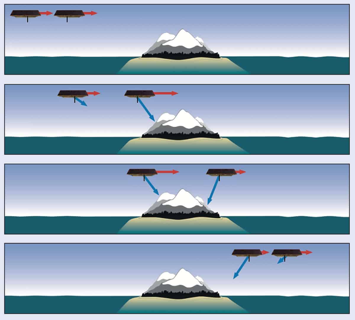
However, all of these factors were just “noise” to be filtered out. The really important influence on the inter-satellite distance – the force that the experiment was designed to measure – was gravity, which increased or decreased as the spacecraft crossed contour lines on the Earth’s geoid. If, say, the satellites’ orbit carried them towards a mass concentration in the Earth below, the leading spacecraft would be the first to feel the greater tug of gravity, which would perturb its trajectory and extend the separation minutely but measurably. When the pair had moved on so that the mass concentration was between them, it would now be the trailing satellite’s turn to feel the extra tug, while the leading satellite was pulled back in its orbit (figure 1).
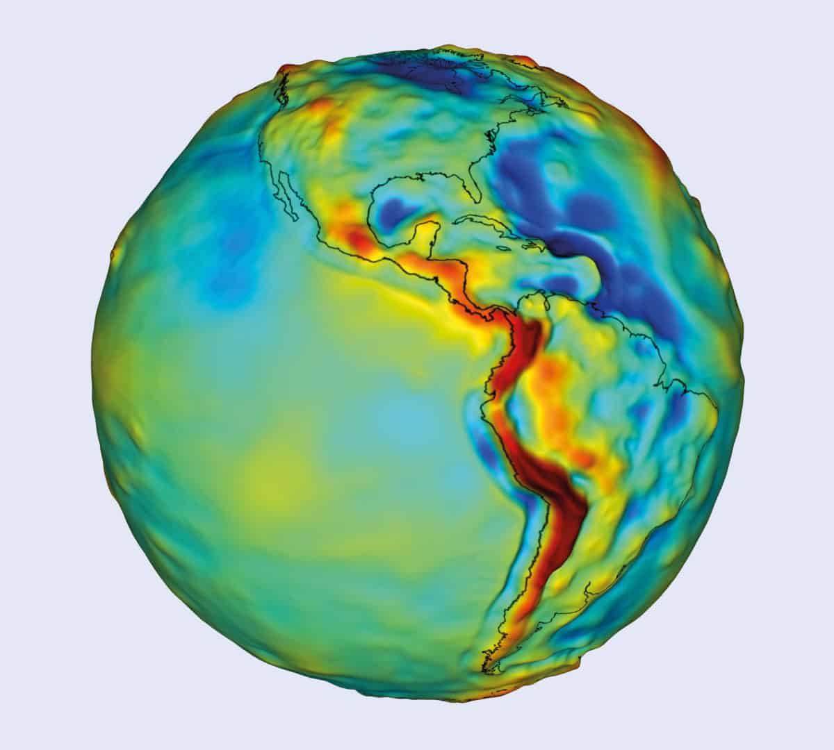
Circling the Earth 16 times a day and achieving near-total global coverage every 30 days, the GRACE satellites – month by month and year by year – generated a map of where the two craft were pulled apart and where they bunched up. Mission scientists were then able to translate these data into an increasingly detailed picture of the planet’s gravitational field (figure 2).
The initial sketch of the mean gravity field produced by the experiment depicted the Earth’s large-scale geological structure: mountains, by definition, are big, and the gravitational signatures of such features were correspondingly easy to identify. Tracking the relatively small month-to-month changes in how water is distributed over oceans and continents, on the other hand, was a harder proposition.
The general locations of the satellites were measured using the Global Positioning System (GPS). But spotting the variation in satellite separation – and therefore gravity – associated with, for example, a depleted aquifer or a rising lake, required a sub-micron precision that GPS could not provide. Instead, the experiment sent a microwave beam from one satellite to the other, where it interfered with a reference beam on that craft. Changes in the inter-satellite distance would alter the relative phase of the two beams, revealing the shift as a change in the interference pattern.
Ascertaining the satellites’ relative motion so precisely was only half the challenge, however. Also crucial was to carefully account for all the other, non-gravitational sources of perturbation, which would otherwise have overwhelmed the gravity signal. At the initial 490 km orbit height, the biggest of these effects was solar-radiation pressure, which fluctuated constantly as the satellites passed in and out of the Earth’s shadow. This also created a cycle of warming and cooling, requiring sensors to measure each satellite’s thermal expansion. Without this information, any change in the dimensions of one of the spacecraft could have been mistaken for a gravitational effect on the distance between them.
Another significant non-gravitational force that had to be accounted for as the mission progressed was aerodynamic resistance on the GRACE satellites from the Earth’s tenuous upper atmosphere. As with all orbiting bodies, there was a positive feedback effect: the drag made the craft lose height, which in turn made them travel through a denser atmosphere, which led to more drag and so on. Indeed, by the end of 2017 when the two craft finally stopped operating, the satellites were orbiting barely 300 km above the Earth’s surface.
To compensate for all of these non-gravitational forces, each satellite had at its centre a 50 g “proof mass” suspended electrostatically within a cage. Electrodes in the walls of this container corralled the mass to within 30 μm of the satellite’s centre of mass, and simultaneously measured any displacement. Non-gravitational forces applied to the satellite body deflected the proof mass relative to its cage, whereas gravitational perturbations affected the entire set-up equally. Any change in distance that could not be attributed to some non-gravitational force on one of the satellites was therefore taken to be an indicator of unevenness in the geoid.
Watery changes
With the confounding effects removed, the precision of the distance measurement meant that GRACE was sensitive to changes in strength of gravity on the order of a few microns per second squared, or less than a millionth of the value at the surface (roughly 9.81 m s–2). Members of the GRACE team could therefore spot changes in gravitational strength caused by the water level in a large lake or aquifer rising or falling by as little as one centimetre. Every month, they compiled such changes in the Earth’s mass distribution and made the updated map available to researchers around the world.
One of those scientists is Matthew Rodell, head of the Hydrological Sciences Laboratory at NASA’s Goddard Space Flight Center in Maryland, US, who has used these data to map the changing availability of fresh water across the planet, including regions that would otherwise be hard to access. “GRACE revealed and quantified groundwater depletion associated with irrigated agriculture in northern India, the North China Plain and parts of the Middle East, among others,” says Rodell.
Writing in a recent paper in Nature (557 651), he and his team quantified dozens of global trends in freshwater distribution that are expected to affect food and water security in coming decades, and that could spark conflict if not managed carefully. The changes were a mix of natural, climate-change-related and directly human-caused effects, and the work simultaneously captured processes as diverse as ice-cap loss in Greenland and Antarctica, groundwater extraction in the Middle East, and the damming of rivers in China.
This ability to spot links between regional trends, which is a vital part of GRACE’s observations, is illustrated by a discovery made by Rodell’s colleagues at the Jet Propulsion Laboratory (JPL) in California (Geophysical Research Letters 39 L19602). They found that the global mean sea level, which had previously been steadily rising by about 3 mm a year, suddenly dropped between 2010 and 2011 by 5 mm. Carmen Boening from JPL, who began pondering the puzzle with collaborators at JPL, the National Center for Atmospheric Research and the University of Colorado at Boulder, wanted to know if the drop was related to ocean cooling or whether there was simply less water in the ocean.
Using GRACE data, Boening and her colleagues found that the sea-level fall really was due to missing mass, and that it was balanced by a corresponding increase in water stored on land. It turned out that the onset of La Niña conditions in the Pacific – a cyclical variation in ocean-surface temperature – had caused so much rain over Australia, south-east Asia and northern South America that the oceans were temporarily depleted, and the continents made measurably more massive. By 2012 the effect had ended and the rising trend, associated with global warming, had resumed. “So by using GRACE to weigh the ocean, we confirmed that there was less water there, which must have moved to the continents,” Boening says.
Following the trend
The two satellites making up the original GRACE mission were designed to last for just five years, with operations scheduled to end in 2007. Sensitive electronics can only take so much radiation and thermal cycling before they start to break down, and the spacecraft had no means to maintain their orbits in the face of aerodynamic drag. However, in a fashion familiar to fans of NASA’s Mars rover fleet, the GRACE scientists over-delivered, and the mission kept returning data until late 2017, shortly before the two satellites fell from orbit and burned up in the Earth’s atmosphere.
But the mission is not yet over. Recognizing the importance of obtaining further measurements, in 2011 NASA initiated a successor to GRACE, known as the GRACE Follow-On (GRACE-FO). With the US National Academy of Sciences also recognizing in its 2017–2027 Decadal Survey for Earth Science and Applications from Space that mass-change measurements are vital for tracking long-term trends in the hydrosphere, GRACE-FO was duly launched in May 2018 from the Vandenberg Air Force Base in California. To ensure continuity, GRACE-FO essentially duplicates the original experiment, but with a few minor improvements derived from lessons learned along the way.
The most novel aspect is the addition of a technology-demonstration instrument – a laser interferometer for measuring the inter-satellite separation. Developed by researchers from JPL as well as the Max Planck Institute for Gravitational Physics in Hannover and the Leibniz Universität Hannover, the device works on the same principle as the microwave-based method used by the original GRACE craft. It should, however, deliver a precision a hundred times greater because of the beam’s shorter wavelength. “It’s a really incredible piece of technology,” says GRACE-FO project scientist Frank Webb from the JPL. “The sensitivity limit is at the hundreds-of-picometres level, which is about half the size of a water molecule – over a distance of 200 km.”
In the current set-up, other sources of error are too large to do justice to the new instrument, so the increased precision cannot be fully utilized. Indeed, during routine operations, GRACE-FO will employ the same microwave-based method used by the original satellites. The laser interferometer is intended only as a validation of the technology for future missions, which will be able to make better use of the device to measure mass changes on the ground with greater accuracy and resolution. Even so, Webb will be surprised if scientists do not find some way to relate test data from the new device to mass change on the Earth. “The scientists are pretty clever, and they should be able to tease out a little more information from this new capability,” he says.
GRACE-FO is slated to work for five years, but whether it can continue working for as long as its predecessor will depend in part on the strength of the next cycle of solar activity, which will start in late 2019. When the Sun is especially active, the increase in emitted ultraviolet radiation adds energy to the Earth’s upper atmosphere. This makes the atmosphere “puff up”, increasing the drag in low Earth orbit and accelerating orbital decay. The craft would then burn up, as its predecessors did, albeit much sooner. “A strong solar cycle will push the satellites lower, earlier,” Webb says.
Follow on following on
Not content with GRACE-FO as a successor to GRACE, there are already plans for a follow-on to the follow-on. These missions will not only continue the geoid observations, but will also incorporate design changes that minimize uncertainty from other quarters, such as the sensitivity of the accelerometer, letting scientists make full use of the increased resolution afforded by the laser interferometer. This will let researchers measure even smaller mass changes over finer spatial scales, potentially revealing additional trends not glimpsed by the satellites launched so far.
And while GRACE-FO – and its successors – will measure changes in the Earth’ gravity field, a similar device could be used by another mission to observe gravitational signals from beyond. That’s because the successful demonstration on GRACE-FO is a major milestone in the development of the European Space Agency’s Laser Interferometer Space Antenna (LISA). Planned for launch in 2034, LISA will comprise three satellites arranged at the corners of a triangle 2.5 million kilometres on a side. Circling the Sun far from the noisy environment of low Earth orbit, the interferometer used on this mission will be able to detect a change in distance of just picometres – sufficient to spot the infinitesimal flexing of space due to the passage of gravitational waves from across the universe.
Results from the GRACE-FO demonstration will provide a practical lesson on how to operate, diagnose and, if necessary, debug the instrument after launch. Members of the LISA team – many of whom also work on GRACE-FO – will be watching keenly in preparation for when they turn their gravitational gaze outward from the Earth.